| |
Presidential
Candidate | Vice Presidential
Candidate | Political
Party | Popular Vote | Electoral Vote |
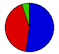
 | Richard Nixon | Spiro Agnew | Republican |
486,686 |
52.45% | 6 |
 | George McGovern | R. Sargent Shriver | Democrat |
392,760 |
42.33% | 0 |
 | John Schmitz | Thomas Anderson | Independent |
46,211 |
4.98% | 0 |
 | Write-ins | - | - |
2,289 |
0.25% | 0 |
 |
Map Key
| Turnout
 |  |  |
|
| Maps |  |  | | Pop. (m) | | Rep. (m) | | Dem. (m) | | Swg (m) | | Tnd (m) |
| |
| Demographic Data
| 1980 Population: | 2,633,156 | Enum. | 1980 Population Density: | 10.6 | persons/km2 | | 1972 Population: | 2,195,219 | Est. | 1972 Population Density: | 8.8 | persons/km2 | | 1970 Population: | 2,091,533 | Enum. | 1970 Population Density: | 8.4 | persons/km2 | | Total Electoral Vote: | 6 | | Electoral Vote Density: | 365,870 | persons/EV | | Land Area (2000): | 248,631 | km2 | Annual Pop Growth Rate: | 2.3 | % |
| Election Data and Statistics:
| Election Tools
- Atlas Forum Image Code for Maps: County, Pop, Tnd, Swg
Data Sources:
- Source for Popular Vote data: Oregon Secretary of State. Elections Division, comp., Official Abstract of Votes General Election 1972 (Salem, 1973)
- Source for Population data: U.S. Census Bureau.
| Results for and Individual County:
|
|
| |


