| |
Presidential
Candidate | Vice Presidential
Candidate | Political
Party | Popular Vote | Electoral Vote |
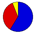
 | William Taft | James Sherman | Republican |
67,536 |
58.84% | 4 |
 | William Bryan | John Kern | Democrat |
40,266 |
35.08% | 0 |
 | Eugene Chafin | Aaron Watkins | Prohibition |
4,039 |
3.52% | 0 |
| Eugene Debs | Benjamin Hanford | Socialist |
2,846 |
2.48% | 0 |
| Thomas Hisgen | John Graves | Scales of Justice |
88 |
0.08% | 0 |
 |
Map Key
| > 40% |
 |
 |
| > 50% |
 |
 |
| > 60% |
 |
 |
| > 70% |
|
 |
| > 80% |
|
 |
| Turnout
 |  |  |
|
| Maps | County Map (m) |  |
| |
| Demographic Data
| 1910 Population: | 583,888 | Enum. | 1910 Population Density: | 3.0 | persons/km2 | | 1900 Population: | 401,570 | Enum. | 1900 Population Density: | 2.0 | persons/km2 | | Total Electoral Vote: | 4 | | | Land Area (2000): | 196,540 | km2 | Annual Pop Growth Rate: | 3.8 | % |
| Election Data and Statistics:
- County Data (Table) (m)
- County Data (Graphs) (m)
|
| | Election Tools
- Atlas Forum Image Code for Maps: County
Data Sources:
- Source for Popular Vote data: South Dakota Secretary of State, comp., "Official Vote of South Dakota by Counties November Election, 1908," South Dakota Legislative Manual 1909 (Pierre: State Publishing Company, 1909)
- Source for Population data: U.S. Census Bureau.
| Results for and Individual County:
|
|
| |


