Home
2024
Election Results
Election Info
Weblog
Forum
Wiki
Search
Email
Login
Site Info
Store
1994 Senatorial Republican Primary Election Results - Washington
Note: The Google advertisement links below may advocate political positions that this site does not endorse.
Data for this Contest was Contributed by on 2010-08-02
Senatorial
Candidate
Political
Party
Popular Vote
Slade Gorton
Republican
492,251
92.06%
Warren E. Hanson
Republican
26,628
4.98%
Mike The Mover
Republican
11,403
2.13%
(first name not provided) Marshall
Republican
4,401
0.82%
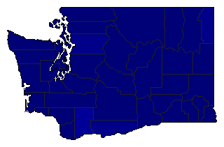
Map Key
> 50%
> 60%
> 70%
> 80%
> 90%
Turnout
Maps
Pop. (m)
Demographic Data
2000 Population:
5,894,121
Enum.
2000 Population Density:
34.2
persons/km
2
1994 Population:
5,375,161
Est.
1994 Population Density:
31.2
persons/km
2
1990 Population:
4,866,669
Enum.
1990 Population Density:
28.2
persons/km
2
Land Area (2000):
172,348
km
2
Annual Pop Growth Rate:
1.9
%
Election Data and Statistics:
County Data (Table)
(m)
County Data (Graphs)
Purchase Detailed Data
Compare State Maps by Year
View All 1994 Washington Maps
Election Tools
Atlas Forum
Image Code for Maps:
County
,
Pop
Data Sources:
Source for Popular Vote data: Washington Secretary of State.
September 1994 Primary
, Washington Secretary of State (www.sos.wa.gov/elections/results_report.aspx?e=14&c=&c2=&t=&t2=&p=&p2=&y=) (accessed 02 Aug 2010)
Source for Population data: U.S. Census Bureau.
Results for and Individual County:
(m)
Choose Year
2010
2006
2004
2000
1998
1992
1988
1976
1970
1940
1934
1928
Choose Office
Choose State
California
Maryland
Oklahoma
Texas
West Virginia
Wisconsin
Washington Election Results Home
-
National Results for 1994
-
Use Frame Navigation
Login
Terms of Use
-
DCMA Policy
-
Privacy Policy and Cookies
©
Dave Leip's Atlas of U.S. Elections, LLC 2019 All Rights Reserved


