Home
2024
Election Results
Election Info
Weblog
Forum
Wiki
Search
Email
Login
Site Info
Store
2002 Gubernatorial Democratic Primary Election Results - Wisconsin
Note: The Google advertisement links below may advocate political positions that this site does not endorse.
Data for this Contest was Contributed by on 2007-01-06
Gubernatorial
Candidate
Political
Party
Popular Vote
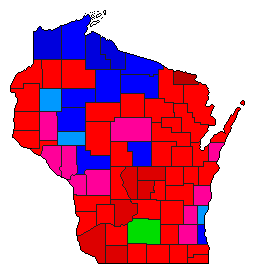
Jim Doyle
Democratic
212,066
38.30%
Tom Barrett
Democratic
190,605
34.43%
Kathleen Falk
Democratic
150,161
27.12%
Scattering
-
803
0.15%
Map Key
> 30%
> 40%
> 50%
> 60%
Turnout
Maps
Demographic Data
2010 Population:
5,686,986
Enum.
2010 Population Density:
40.4
persons/km
2
2002 Population:
5,445,162
Est.
2002 Population Density:
38.7
persons/km
2
2000 Population:
5,363,675
Enum.
2000 Population Density:
38.1
persons/km
2
Land Area (2000):
140,663
km
2
Annual Pop Growth Rate:
0.6
%
Election Data and Statistics:
County Data (Table)
(m)
County Data (Graphs)
Purchase Detailed Data
Compare State Maps by Year
View All 2002 Wisconsin Maps
Election Tools
Atlas Forum
Image Code for Maps:
County
,
Pop
Data Sources:
Source for Popular Vote data: Wisconsin State Elections Board.
Canvass - County Totals, Fall Democratic Primary Election - 09/10/2002
, Wisconsin State Elections Board (http://165.189.88.185/docview.asp?docid=1588&locid=47) (accessed 06 Jan 2007)
Source for Population data: U.S. Census Bureau.
Results for and Individual County:
Adams County
Ashland County
Barron County
Bayfield County
Brown County
Buffalo County
Burnett County
Calumet County
Chippewa County
Clark County
Columbia County
Crawford County
Dane County
Dodge County
Door County
Douglas County
Dunn County
Eau Claire County
Florence County
Fond du Lac County
Forest County
Grant County
Green County
Green Lake County
Iowa County
Iron County
Jackson County
Jefferson County
Juneau County
Kenosha County
Kewaunee County
La Crosse County
Lafayette County
Langlade County
Lincoln County
Manitowoc County
Marathon County
Marinette County
Marquette County
Menominee County
Milwaukee County
Monroe County
Oconto County
Oneida County
Outagamie County
Ozaukee County
Pepin County
Pierce County
Polk County
Portage County
Price County
Racine County
Richland County
Rock County
Rusk County
St. Croix County
Sauk County
Sawyer County
Shawano County
Sheboygan County
Taylor County
Trempealeau County
Vernon County
Vilas County
Walworth County
Washburn County
Washington County
Waukesha County
Waupaca County
Waushara County
Winnebago County
Wood County
Choose Year
2018
2012
Choose Office
Choose State
Alabama
Arkansas
California
Florida
Hawaii
Idaho
Illinois
Michigan
Minnesota
Nebraska
Nevada
New Hampshire
New York
Oklahoma
Oregon
Pennsylvania
Texas
Wyoming
Wisconsin Election Results Home
-
National Results for 2002
-
Use Frame Navigation
Login
Terms of Use
-
DCMA Policy
-
Privacy Policy and Cookies
©
Dave Leip's Atlas of U.S. Elections, LLC 2019 All Rights Reserved


