| |
Secretary of State
Candidate | Political
Party | Popular Vote |
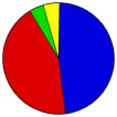
 | James Cowie | Republican |
87,701 |
47.61% |
 | Horace W. Havens | Democratic |
79,842 |
43.34% |
 | Charles H. Norris | Socialist |
7,910 |
4.29% |
 | W. G. Templeton | Prohibition |
4,119 |
2.24% |
| David A. Mills | People's |
3,678 |
2.00% |
| Andrew Ohman | Socialist Labor |
968 |
0.53% |
 |
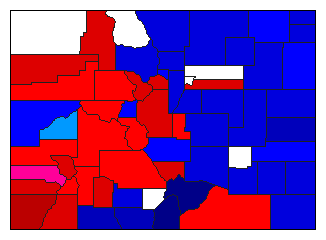
Map Key
| > 30% |
 |
 |
| > 40% |
 |
 |
| > 50% |
 |
 |
| > 60% |
 |
 |
| > 80% |
 |
 |
| Turnout
 |  |
|
|
| Election Notes:
- The stated total for Havens is 79,842 but the county figures add up to 79,978. The stated total for Cowie is 87,701 but the county figures add up to 87,936. The stated total for Norris is 7,910 but the county figures add up to 7,906. The stated total for Templeton is 4,119 but the county figures add up to 4,320. The stated total for Mills is 3,678 but the county figures add up to 3,687.
- Candidates' party affiliations obtained from the 11/12/1902 Weekly Courier (of Fort Collins). https://www.coloradohistoricnewspapers.org/?a=d&d=TWC19021112.1.6&e=-------en-20--1--img-txIN%7ctxCO%7ctxTA--------0------
| Demographic Data
| 1910 Population: | 799,024 | Enum. | 1910 Population Density: | 3.0 | persons/km2 | | 1900 Population: | 539,700 | Enum. | 1900 Population Density: | 2.0 | persons/km2 | | Land Area (2000): | 268,627 | km2 | Annual Pop Growth Rate: | 4.0 | % |
| Election Data and Statistics:
- County Data (Table) (m)
- County Data (Graphs) (m)
|
| | Election Tools
- Atlas Forum Image Code for Maps: County
Data Sources:
- Source for Popular Vote data: Colorado Secretary of State. State of Colorado 1903 Legislative Manual, Colorado Secretary of State (https://babel.hathitrust.org/cgi/pt?id=hvd.li2211&view=1up&seq=187) (accessed 11 Dec 2023)
- Source for Population data: U.S. Census Bureau.
| Results for and Individual County:
|
|
| |


