| |
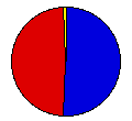
Presidential
Candidate | Vice Presidential
Candidate | Political
Party | Popular Vote | Electoral Vote |
 | Wendell Willkie | Charles McNary | Republican |
279,576 |
50.92% | 6 |
 | Franklin Roosevelt | Henry Wallace | Democrat |
265,554 |
48.37% | 0 |
 | Norman Thomas | Maynard Krueger | Socialist |
1,899 |
0.35% | 0 |
| Roger Babson | Edgar Moorman | Prohibition |
1,597 |
0.29% | 0 |
| Earl Browder | James Ford | Communist |
378 |
0.07% | 0 |
 |
Map Key
| Turnout
 |  |  |
|
| Maps | County Map (m) |  | | Pop. (m) | | Rep. (m) | | Dem. (m) | | Swg (m) | | Tnd (m) |
| |
| Demographic Data
| 1940 Population: | 1,123,296 | Enum. | 1940 Population Density: | 4.2 | persons/km2 | | 1930 Population: | 1,035,791 | Enum. | 1930 Population Density: | 3.9 | persons/km2 | | Total Electoral Vote: | 6 | | Electoral Vote Density: | 187,216 | persons/EV | | Land Area (2000): | 268,627 | km2 | Annual Pop Growth Rate: | 0.8 | % |
| Election Data and Statistics:
- County Data (Table) (m)
- County Data (Graphs) (m)
|
| | Election Tools
- Atlas Forum Image Code for Maps: County, Pop, Tnd, Swg
Data Sources:
- Source for Popular Vote data: Colorado Secretary of State, comp., State of Colorado Abstract of Votes Cast at the ... General Election Held on the Fifth Day of November A.D., 1940 ... (Denver, 1940)
- Source for Population data: U.S. Census Bureau.
| Results for and Individual County:
|
|
| |


