| |
Presidential
Candidate | Vice Presidential
Candidate | Political
Party | Popular Vote | Electoral Vote |
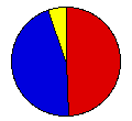
 | Grover Cleveland | Adlai Stevenson | Democrat |
654,868 |
48.99% | 36 |
 | Benjamin Harrison | Whitelaw Reid | Republican |
609,350 |
45.58% | 0 |
 | John Bidwell | James Cranfill | Prohibition |
38,190 |
2.86% | 0 |
| Simon Wing | Charles Matchett | Socialist Labor |
17,956 |
1.34% | 0 |
| James Weaver | James Field | People's |
16,429 |
1.23% | 0 |
 |
Map Key
| Turnout
 |  |  |
|
| Maps | County Map (m) |  |
| |
| Demographic Data
| 1900 Population: | 7,268,894 | Enum. | 1900 Population Density: | 59.4 | persons/km2 | | 1890 Population: | 0 | Enum. | 1890 Population Density: | 0.0 | persons/km2 | | Total Electoral Vote: | 36 | | | Land Area (2000): | 122,283 | km2 | Annual Pop Growth Rate: | 0 | % |
| Election Data and Statistics:
- County Data (Table) (m)
- County Data (Graphs) (m)
|
| | Election Tools
- Atlas Forum Image Code for Maps: County
Data Sources:
- Source for Popular Vote data: New York Secretary of State, Manual for the Use of the Legislature of the State of New York for the Year 1893 (Albany, 1893)
- Source for Population data: U.S. Census Bureau.
| Results for and Individual County:
|
|
| |


