| |
Presidential
Candidate | Vice Presidential
Candidate | Political
Party | Popular Vote | Electoral Vote |
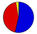
 | William McKinley | Garret Hobart | Republican |
293,336 |
53.77% | 14 |
 | William Bryan | Arthur Sewall | D. P. U. S. |
237,166 |
43.47% | 0 |
 | John Palmer | Simon Buckner | Democrat |
6,923 |
1.27% | 0 |
| Joshua Levering | Hale Johnson | Prohibition |
4,978 |
0.91% | 0 |
| Charles Bentley | James Southgate | National |
1,816 |
0.33% | 0 |
| Other (+) | - | - |
1,366 |
0.25% | 0 |
 |
Map Key
| > 40% |
 |
 |
| > 50% |
 |
 |
| > 60% |
 |
 |
| > 70% |
 |
 |
| > 80% |
|
 |
| Turnout
 |  |  |
|
| Maps | County Map (m) |  |
| |
| Demographic Data
| 1900 Population: | 2,420,982 | Enum. | 1900 Population Density: | 16.5 | persons/km2 | | 1890 Population: | 0 | Enum. | 1890 Population Density: | 0.0 | persons/km2 | | Total Electoral Vote: | 14 | | | Land Area (2000): | 147,121 | km2 | Annual Pop Growth Rate: | 0 | % |
| Election Data and Statistics:
- County Data (Table) (m)
- County Data (Graphs) (m)
|
| | Election Tools
- Atlas Forum Image Code for Maps: County
Data Sources:
- Source for Popular Vote data: Michigan Department of State, comp., "Presidential Vote in Michigan from 1836 to 1912," Michigan Official Directory and Legislative Manual for the Years 1913-1914 (Lansing, 1913)
- Source for Population data: U.S. Census Bureau.
| Results for and Individual County:
|
|
| |


