| |
Presidential
Candidate | Vice Presidential
Candidate | Political
Party | Popular Vote | Electoral Vote |
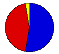
 | William McKinley | Theodore Roosevelt | Republican |
597,985 |
52.83% | 24 |
 | William Bryan | Adlai Stevenson | Democrat |
503,061 |
44.44% | 0 |
 | John Woolley | Henry Metcalf | Prohibition |
17,626 |
1.56% | 0 |
| Eugene Debs | Job Harriman | Social Democrat |
9,687 |
0.86% | 0 |
| Joseph Maloney | Valentine Remmel | Socialist Labor |
1,373 |
0.12% | 0 |
| Wharton Barker | Ignatius Donnelly | People's |
1,141 |
0.10% | 0 |
| Seth Ellis | Samuel Nicholson | United Reform |
672 |
0.06% | 0 |
| Jonah Leonard | David Martin | United Christian |
352 |
0.03% | 0 |
 |
Map Key
| Turnout
 |  |  |
|
| Maps | County Map (m) |  |
| |
| Election Notes:
- The vote given is that cast for the elector receiving the highest aggregate vote cast in each county for the elector by the party represented.
| Demographic Data
| 1900 Population: | 4,821,550 | Enum. | 1900 Population Density: | 33.5 | persons/km2 | | 1890 Population: | 0 | Enum. | 1890 Population Density: | 0.0 | persons/km2 | | Total Electoral Vote: | 24 | | Electoral Vote Density: | 200,898 | persons/EV | | Land Area (2000): | 143,961 | km2 | Annual Pop Growth Rate: | 0 | % |
| Election Data and Statistics:
- County Data (Table) (m)
- County Data (Graphs) (m)
|
| | Election Tools
- Atlas Forum Image Code for Maps: County
Data Sources:
- Source for Popular Vote data: Illinois Secretary of State, comp., "Vote for President," Official Vote of the State of Illinois cast at the General Election, November 6, 1900 (Springfield: Phillips Bros., State Printers, 1900)
- Source for Population data: U.S. Census Bureau.
| Results for and Individual County:
|
|
| |


