| |
Presidential
Candidate | Vice Presidential
Candidate | Political
Party | Popular Vote | Electoral Vote |
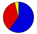
 | William McKinley | Theodore Roosevelt | Republican |
190,461 |
60.21% | 9 |
 | William Bryan | Adlai Stevenson | Dem.-People's |
112,901 |
35.69% | 0 |
 | John Woolley | Henry Metcalf | Prohibition |
8,555 |
2.70% | 0 |
| Eugene Debs | Job Harriman | Social Democrat |
3,065 |
0.97% | 0 |
| Joseph Maloney | Valentine Remmel | Socialist Labor |
1,329 |
0.42% | 0 |
 |
Map Key
| > 40% |
 |
 |
| > 50% |
 |
 |
| > 60% |
 |
 |
| > 70% |
 |
 |
| > 80% |
|
 |
| Turnout
 |  |  |
|
| Maps | County Map (m) |  |
| |
| Demographic Data
| 1900 Population: | 1,751,394 | Enum. | 1900 Population Density: | 8.5 | persons/km2 | | 1890 Population: | 0 | Enum. | 1890 Population Density: | 0.0 | persons/km2 | | Total Electoral Vote: | 9 | | Electoral Vote Density: | 194,599 | persons/EV | | Land Area (2000): | 206,189 | km2 | Annual Pop Growth Rate: | 0 | % |
| Election Data and Statistics:
- County Data (Table) (m)
- County Data (Graphs) (m)
|
| | Election Tools
- Atlas Forum Image Code for Maps: County
Data Sources:
- Source for Popular Vote data: Minnesota Secretary of State, "Official Canvass by the State Board of Canvassers for Presidential Electors, Election Held November 6, 1900," The Legislative Manual of the State of Minnesota 1901 (St. Paul, 1901)
- Source for Population data: U.S. Census Bureau.
| Results for and Individual County:
|
|
| |


