| |
Presidential
Candidate | Vice Presidential
Candidate | Political
Party | Popular Vote | Electoral Vote |
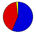
 | William McKinley | Theodore Roosevelt | Republican |
54,530 |
56.73% | 4 |
 | William Bryan | Adlai Stevenson | Fusion |
39,544 |
41.14% | 0 |
 | John Woolley | Henry Metcalf | Prohibition |
1,542 |
1.60% | 0 |
| Wharton Barker | Ignatius Donnelly | Populist |
339 |
0.35% | 0 |
| Eugene Debs | Job Harriman | Social Democrat |
169 |
0.18% | 0 |
 |
Map Key
| Turnout
 |  |  |
|
| Maps | County Map (m) |  |
| |
| Demographic Data
| 1900 Population: | 401,570 | Enum. | 1900 Population Density: | 2.0 | persons/km2 | | 1890 Population: | 0 | Enum. | 1890 Population Density: | 0.0 | persons/km2 | | Total Electoral Vote: | 4 | | Electoral Vote Density: | 100,393 | persons/EV | | Land Area (2000): | 196,540 | km2 | Annual Pop Growth Rate: | 0 | % |
| Election Data and Statistics:
- County Data (Table) (m)
- County Data (Graphs) (m)
|
| | Election Tools
- Atlas Forum Image Code for Maps: County
Data Sources:
- Source for Popular Vote data: South Dakota Secretary of State, comp., "Official Vote of South Dakota by Counties November Election, 1900," South Dakota Legislative Manual 1909 (Pierre: State Publishing Company, 1909)
- Source for Population data: U.S. Census Bureau.
| Results for and Individual County:
|
|
| |


