| |
Presidential
Candidate | Vice Presidential
Candidate | Political
Party | Popular Vote | Electoral Vote |
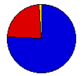
 | William McKinley | Theodore Roosevelt | Republican |
42,569 |
75.73% | 4 |
 | William Bryan | Adlai Stevenson | Democrat |
12,849 |
22.86% | 0 |
 | John Woolley | Henry Metcalf | Prohibition |
383 |
0.68% | 0 |
| Wharton Barker | Ignatius Donnelly | People's |
367 |
0.65% | 0 |
| Other (+) | - | - |
44 |
0.08% | 0 |
 |
Map Key
| Turnout
 |  |  |
|
| Maps | County Map (m) |  |
| |
| Demographic Data
| 1900 Population: | 343,641 | Enum. | 1900 Population Density: | 14.3 | persons/km2 | | 1890 Population: | 0 | Enum. | 1890 Population Density: | 0.0 | persons/km2 | | Total Electoral Vote: | 4 | | Electoral Vote Density: | 85,910 | persons/EV | | Land Area (2000): | 23,956 | km2 | Annual Pop Growth Rate: | 0 | % |
| Election Data and Statistics:
- County Data (Table) (m)
- County Data (Graphs) (m)
|
| | Election Tools
- Atlas Forum Image Code for Maps: County
Data Sources:
- Source for Popular Vote data: Vermont Secretary of State, "State of Vermont Canvass of Votes for Electors of President and Vice President," (Rutland, 1900)
- Source for Population data: U.S. Census Bureau.
| Results for and Individual County:
|
|
| |


