| |
Presidential
Candidate | Vice Presidential
Candidate | Political
Party | Popular Vote | Electoral Vote |
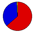
 | Franklin Roosevelt | John Garner | Democratic |
1,025,406 |
63.69% | 15 |
 | Herbert Hoover | Charles Curtis | Republican |
564,713 |
35.08% | 0 |
 | Norman Thomas | James Maurer | Socialist |
16,374 |
1.02% | 0 |
| William Upshaw | Frank Regan | Prohibition |
2,429 |
0.15% | 0 |
| William Foster | James Ford | Communist |
568 |
0.04% | 0 |
| Verne Reynolds | John Aiken | Socialist Labor |
404 |
0.03% | 0 |
 |
Map Key
| Turnout
 |  |  |
|
| Maps | County Map (m) |  | | Dem. (m) | | Rep. (m) | | Swg (m) | | Tnd (m) |
| |
| Demographic Data
| 1940 Population: | 3,784,664 | Enum. | 1940 Population Density: | 21.2 | persons/km2 | | 1930 Population: | 3,629,367 | Enum. | 1930 Population Density: | 20.3 | persons/km2 | | Total Electoral Vote: | 15 | | | Land Area (2000): | 178,414 | km2 | Annual Pop Growth Rate: | 0.4 | % |
| Election Data and Statistics:
- County Data (Table) (m)
- County Data (Graphs) (m)
|
| | Election Tools
- Atlas Forum Image Code for Maps: County, Tnd, Swg
Data Sources:
- Source for Popular Vote data: Missouri Secretary of State, "General Election Returns Vote for President, By Counties, at General Election November 8, 1932," State of Missouri Official Manual for the Years 1933-1934 (Jefferson City, 1933)
- Source for Population data: U.S. Census Bureau.
| Results for and Individual County:
|
|
| |


