| |
Presidential
Candidate | Vice Presidential
Candidate | Political
Party | Popular Vote | Electoral Vote |
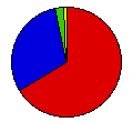
 | Franklin Roosevelt | John Garner | Democrat |
459,579 |
66.38% | 8 |
 | Alfred Landon | Frank Knox | Republican |
206,892 |
29.88% | 0 |
 | William Lemke | Thomas O'Brian | Union |
17,463 |
2.52% | 0 |
| Norman Thomas | George Nelson | Socialist |
3,496 |
0.50% | 0 |
| Earl Browder | James Ford | Communist |
1,907 |
0.28% | 0 |
| William Pelley | Willard Kemp | Christian |
1,598 |
0.23% | 0 |
| D. Leigh Colvin | Claude Watson | Prohibition |
1,041 |
0.15% | 0 |
| John Aiken | Emil Teichert | Socialist Labor |
362 |
0.05% | 0 |
 |
Map Key
| > 40% |
 |
 |
| > 50% |
 |
|
| > 60% |
 |
|
| > 70% |
 |
|
| > 80% |
 |
|
| Turnout
 |  |  |
|
| Maps | County Map (m) |  | | Dem. (m) | | Rep. (m) | | Swg (m) | | Tnd (m) |
| |
| Demographic Data
| 1940 Population: | 1,736,191 | Enum. | 1940 Population Density: | 10.1 | persons/km2 | | 1930 Population: | 1,563,396 | Enum. | 1930 Population Density: | 9.1 | persons/km2 | | Total Electoral Vote: | 8 | | | Land Area (2000): | 172,348 | km2 | Annual Pop Growth Rate: | 1.1 | % |
| Election Data and Statistics:
- County Data (Table) (m)
- County Data (Graphs) (m)
|
| | Election Tools
- Atlas Forum Image Code for Maps: County, Tnd, Swg
Data Sources:
- Source for Popular Vote data: Washington Secretary of State, comp., "Presidential Candidates," Abstract of Votes Polled in the State of Washington at ... General Election, Nov. 3, 1936 (Olympia, 1936)
- Source for Population data: U.S. Census Bureau.
| Results for and Individual County:
|
|
| |


