| |
Presidential
Candidate | Vice Presidential
Candidate | Political
Party | Popular Vote | Electoral Vote |
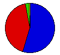
 | Richard Nixon | Spiro Agnew | Republican |
4,602,096 |
55.00% | 45 |
 | George McGovern | R. Sargent Shriver | Democrat |
3,475,847 |
41.54% | 0 |
 | John Schmitz | Thomas Anderson | American Ind. |
232,554 |
2.78% | 0 |
| Benjamin Spock | Julius Hobson | Peace & Freedom |
55,167 |
0.66% | 0 |
| John Hospers | Theodora Nathan | Write-in |
980 |
0.01% | 0 |
| Linda Jenness | Andrew Pulley | Write-in |
574 |
0.01% | 0 |
| Gus Hall | Jarvis Tyner | Write-in |
373 |
0.00% | 0 |
| Louis Fisher | G. Gunderson | Write-in |
197 |
0.00% | 0 |
| E. Harold Munn | Marshall Uncapher | Write-in |
53 |
0.00% | 0 |
| Gabriel Green | Daniel Fry | Write-in |
21 |
0.00% | 0 |
 |
Map Key
| Turnout
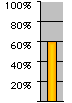 |  |  |
|
| Maps | 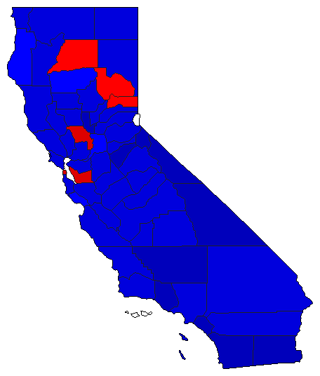 |  | | Pop. (m) | | Rep. (m) | | Dem. (m) | | Swg (m) | | Tnd (m) |
| |
| Demographic Data
| 1980 Population: | 23,667,765 | Enum. | 1980 Population Density: | 58.6 | persons/km2 | | 1972 Population: | 20,584,794 | Est. | 1972 Population Density: | 51.0 | persons/km2 | | 1970 Population: | 19,971,069 | Enum. | 1970 Population Density: | 49.4 | persons/km2 | | Total Electoral Vote: | 45 | | Electoral Vote Density: | 457,440 | persons/EV | | Land Area (2000): | 403,933 | km2 | Annual Pop Growth Rate: | 1.7 | % |
| Election Data and Statistics:
| Election Tools
- Atlas Forum Image Code for Maps: County, Pop, Tnd, Swg
Data Sources:
- Source for Popular Vote data: California Secretary of State, comp., Statement of Vote General Election November 7, 1972 (Sacramento, 1972)
- Source for Population data: U.S. Census Bureau.
| Results for and Individual County:
|
|
| |


