| |
Presidential
Candidate | Vice Presidential
Candidate | Political
Party | Popular Vote | Electoral Vote |
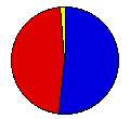
 | Gerald Ford | Robert Dole | Republican |
1,893,742 |
51.83% | 21 |
 | James Carter | Walter Mondale | Democrat |
1,696,714 |
46.44% | 0 |
 | Eugene McCarthy | Patricia Weymouth | Independent |
47,905 |
1.31% | 0 |
| Other (+) | - | - |
15,388 |
0.42% | 0 |
 |
Map Key
| Turnout
 |  |  |
|
| Maps | 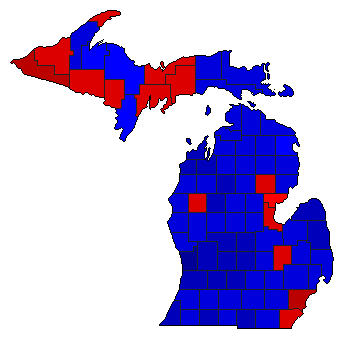 |  | | Pop. (m) | | Rep. (m) | | Dem. (m) | | Swg (m) | | Tnd (m) |
| |
| Demographic Data
| 1980 Population: | 9,262,044 | Enum. | 1980 Population Density: | 63.0 | persons/km2 | | 1976 Population: | 9,117,481 | Est. | 1976 Population Density: | 62.0 | persons/km2 | | 1970 Population: | 8,881,826 | Enum. | 1970 Population Density: | 60.4 | persons/km2 | | Total Electoral Vote: | 21 | | Electoral Vote Density: | 434,166 | persons/EV | | Land Area (2000): | 147,121 | km2 | Annual Pop Growth Rate: | 0.4 | % |
| Election Data and Statistics:
| Election Tools
- Atlas Forum Image Code for Maps: County, Pop, Tnd, Swg
Data Sources:
- Source for Popular Vote data: Michigan Department of Management and Budget, "Official Canvass of Votes, General Election President and Vice President of the United States," Michigan Manual 1977-1978 (Lansing, 1977)
- Source for Population data: U.S. Census Bureau.
| Results for and Individual County:
|
|
| |


