| |
Presidential
Candidate | Vice Presidential
Candidate | Political
Party | Popular Vote | Electoral Vote |
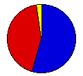
 | Gerald Ford | Robert Dole | Republican |
102,085 |
54.34% | 3 |
 | James Carter | Walter Mondale | Democrat |
81,044 |
43.14% | 0 |
 | Eugene McCarthy | - | McCarthy '76 |
4,001 |
2.13% | 0 |
| Peter Camejo | Willie Mae Reid | Soc. Workers |
430 |
0.23% | 0 |
| Lyndon LaRouche | R. Wayne Evans | U.S. Labor |
196 |
0.10% | 0 |
| Write-ins | - | - |
91 |
0.05% | 0 |
| Roger MacBride | David Bergland | - |
4 |
0.00% | 0 |
| Thomas Anderson | Rufus Shackelford | - |
2 |
0.00% | 0 |
| Margaret Wright | Benjamin Spock | - |
2 |
0.00% | 0 |
 |
Map Key
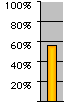
| Turnout
 |  |  |
|
| Maps | 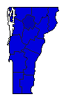 |  | | Pop. (m) | | C.D. (m) | | Rep. (m) | | Dem. (m) | | Swg (m) | | Tnd (m) |
| |
| Election Notes:
- Carter vote is the fusion of the Democrat and Independent Vermonters parties.
| Demographic Data
| 1980 Population: | 511,456 | Enum. | 1980 Population Density: | 21.3 | persons/km2 | | 1976 Population: | 485,144 | Est. | 1976 Population Density: | 20.3 | persons/km2 | | 1970 Population: | 444,732 | Enum. | 1970 Population Density: | 18.6 | persons/km2 | | Total Electoral Vote: | 3 | | Electoral Vote Density: | 161,715 | persons/EV | | Land Area (2000): | 23,956 | km2 | Annual Pop Growth Rate: | 1.4 | % |
| Election Data and Statistics:
- County Data (Table) (m)
- County Data (Graphs)
- Congressional District Data (m)
- Voter Registration & Turnout Data (m)
|
| | Election Tools
- Atlas Forum Image Code for Maps: County, CD, Pop, Tnd, Swg
Data Sources:
- Source for Popular Vote data: Vermont Office of the Secretary of State, Canvass of Votes for Presidential Electors General Election - November 2, 1976 (Rutland, 0)
- Source for Population data: U.S. Census Bureau.
| Results for and Individual County:
|
|
| |


