| |
Presidential
Candidate | Vice Presidential
Candidate | Political
Party | Popular Vote | Electoral Vote |
 | Robert Dole | Jack Kemp | Republican |
769,044 |
50.12% | 9 |
 | William Clinton | Albert Gore Jr. | Democratic |
662,165 |
43.16% | 0 |
 | H. Ross Perot | Pat Choate | Independent |
92,149 |
6.01% | 0 |
 | Harry Browne | Jo Jorgensen | Libertarian |
5,290 |
0.34% | 0 |
| Howard Phillips | Herbert Titus | Independent |
2,365 |
0.15% | 0 |
| Dr. John Hagelin | Dr. V. Tompkins | Natural Law |
1,697 |
0.11% | 0 |
| Write-ins | - | - |
1,123 |
0.07% | 0 |
| James Harris | Laura Garza | Independent |
516 |
0.03% | 0 |
 |
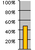
Map Key
| > 40% |
 |
 |
| > 50% |
 |
 |
| > 60% |
 |
 |
| > 70% |
 |
 |
| > 80% |
 |
 |
| Turnout
 |  |  |
|
| Maps | 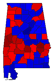 |  |  | | Pop. (m) | | C.D. (m) | | Rep. (m) | | Dem. (m) | | Ind. (m) | | Swg (m) | | Tnd (m) |
| |
| Demographic Data
| 2000 Population: | 4,447,100 | Enum. | 2000 Population Density: | 33.8 | persons/km2 | | 1996 Population: | 4,331,102 | Est. | 1996 Population Density: | 33.0 | persons/km2 | | 1990 Population: | 4,040,389 | Enum. | 1990 Population Density: | 30.7 | persons/km2 | | Total Electoral Vote: | 9 | | Electoral Vote Density: | 481,234 | persons/EV | | Land Area (2000): | 131,426 | km2 | Annual Pop Growth Rate: | 1.0 | % |
| Election Data and Statistics:
| Election Tools
- Atlas Forum Image Code for Maps: County, CD, Pop, Tnd, Swg
Data Sources:
- Source for Popular Vote data: Office of the Secretary of State State of Alabama. Elections Division. Historic Election Results, Office of the Secretary of State State of Alabama. Elections Division (
) (accessed 28 Feb 1999)
- Source for Population data: U.S. Census Bureau.
| Results for and Individual County:
|
|
| |


