Note: The Google advertisement links below may advocate political positions that this site does not endorse.
  Senatorial
Candidate
Political
Party
Popular Vote
Mike RoundsRepublican 276,232 65.74%
Dan AhlersDemocratic 143,987 34.26%
State Seal Map Key
 > 50%
 > 60%
 > 70%
 > 80%
 > 90%
Turnout
Voter Turnout Graph
Vote Pie Chart
Maps
  2020 South Dakota County Map of General Election Results for Senator  
County Button
2000 Button
Pop Button
Cong Dist Button
Per Vote Republican Button
Per Vote Democratic Button
Swing Map Button
Trend Map Button
 
Election Data and Statistics:
Election Tools
Data Sources:
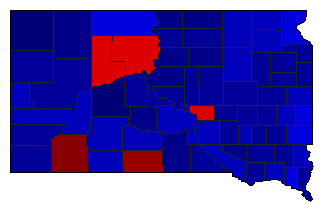
  • Source for Popular Vote data: South Dakota Secretary of State. State of South Dakota Certificate United States Senator, South Dakota Secretary of State (https://sdsos.gov/elections-voting/assets/2020GeneralStateCanvassFinal&Certificate.pdf) (accessed 2020-11-21)
  • Source for Population data: U.S. Census Bureau.
Results for and Individual County:
The 2020 Campaign:


Aurora County Beadle County Bennett County Bon Homme County Brookings County Brown County Brule County Buffalo County Butte County Campbell County Charles Mix County Clark County Clay County Codington County Corson County Custer County Davison County Day County Deuel County Dewey County Douglas County Edmunds County Fall River County Faulk County Grant County Gregory County Haakon County Hamlin County Hand County Hanson County Harding County Hughes County Hutchinson County Hyde County Jackson County Jerauld County Jones County Kingsbury County Lake County Lawrence County Lincoln County Lyman County McCook County McPherson County Marshall County Meade County Mellette County Miner County Minnehaha County Moody County Pennington County Perkins County Potter County Roberts County Sanborn County Spink County Stanley County Sully County Todd County Tripp County Turner County Union County Walworth County Yankton County Ziebach County Oglala Lakota County