| | Presidential
Candidate | Vice Presidential
Candidate | Political
Party | Popular Vote |
|---|
 |
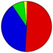
Albert Gore Jr. | Joseph Lieberman | Democratic | | |
5,676 |
50.47% |
 |
George W. Bush | Richard Cheney | Republican | | |
4,456 |
39.62% |
 |
Ralph Nader | Winona LaDuke | Prog./Green | | |
878 |
7.81% |
 |
Patrick Buchanan | Ezola Foster | Reform | | |
109 |
0.97% |
|
Denny Lane | Dale Wilkinson | VT Grassroots | | |
51 |
0.45% |
|
Harry Browne | Art Olivier | Libertarian | | |
34 |
0.30% |
|
Write-ins | - | - | | |
23 |
0.20% |
|
John Hagelin | A. Nat. Goldhaber | Natural Law | | |
7 |
0.06% |
|
Howard Phillips | J. Curtis Frazier | Constitution | | |
6 |
0.05% |
|
David McReynolds | Mary Cal Hollis | Liberty Union | | |
4 |
0.04% |
|
James Harris | Margaret Trowe | Soc. Workers | | |
2 |
0.02% |
 |
Map Key
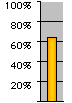
| Turnout
 |
 |
|
| Maps | County Township Map (m) |  |  |
 |
 |
 |
 |
 |
| |
| Demographic Data
| 2000 Population: | 23,233 | Enum. | 2000 Population Density: | 19.5 | persons/km2 | | 1990 Population: | 19,735 | Enum. | 1990 Population Density: | 16.5 | persons/km2 | | Land Area (2000): | 1,194 | km2 | Annual Pop Growth Rate: | 1.6 | % |
| Data and Statistics:
- City and Town Data (Table) (m)
- City and Town Data (Graphs) (m)
- Precinct Data (Table) (m)
- Voter Registration & Turnout Data (m)
|
- Compare County Data by Year (Table) (m)
- Compare County Data by Year (Graphs) (m)
- Compare County Maps by Year (m)
| |
| | |


