| | Presidential
Candidate | Vice Presidential
Candidate | Political
Party | Popular Vote |
|---|
 |
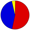
Albert Gore Jr. | Joseph Lieberman | Democratic | | | |
4,826 |
52.94% |
 |
George W. Bush | Richard Cheney | Republican | | | |
3,920 |
43.00% |
 |
Ralph Nader | Winona LaDuke | WI Greens | | | |
217 |
2.38% |
|
Patrick Buchanan | Ezola Foster | Independent | | | |
77 |
0.84% |
|
Howard Phillips | J. Curtis Frazier | Constitution | | | |
25 |
0.27% |
|
Harry Browne | Art Olivier | Libertarian | | | |
24 |
0.26% |
|
Write-ins | - | - | | | |
10 |
0.11% |
|
John Hagelin | A. Nat. Goldhaber | Independent | | | |
8 |
0.09% |
|
Monica Moorehead | Gloria La Riva | Independent | | | |
7 |
0.08% |
|
James Harris | Margaret Trowe | Independent | | | |
2 |
0.02% |
 |
Map Key
| Turnout
 |
 |
|
| Maps | County Township Map (m) |  |
 |
 |
| |
| Demographic Data
| 2000 Population: | 18,643 | Enum. | 2000 Population Density: | 11.1 | persons/km2 | | 1990 Population: | 15,682 | Enum. | 1990 Population Density: | 9.3 | persons/km2 | | Land Area (2000): | 1,678 | km2 | Annual Pop Growth Rate: | 1.7 | % |
| Data and Statistics:
- City and Town Data (Table) (m)
- City and Town Data (Graphs) (m)
- Precinct Data (Table) (m)
|
- Compare County Data by Year (Table) (m)
- Compare County Data by Year (Graphs) (m)
- Compare County Maps by Year (m)
| |
| | |


