| | Presidential
Candidate | Vice Presidential
Candidate | Political
Party | Popular Vote |
|---|
 |
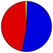
George W. Bush | Richard Cheney | Republican | | |
91,853 |
52.77% |
 |
John Kerry | John Edwards | Democratic-F.L. | | |
80,226 |
46.09% |
 |
Ralph Nader | Peter Camejo | Better Life | | |
978 |
0.56% |
|
Michael Badnarik | Richard Campagna | Libertarian | | |
272 |
0.16% |
|
David Cobb | Patricia LaMarche | Green | | |
232 |
0.13% |
|
Michael Peroutka | Charles Baldwin | Constitution | | |
197 |
0.11% |
|
Write-ins | - | - | | |
146 |
0.08% |
|
Thomas Harens | Jennifer Ryan | Christian Freedom | | |
123 |
0.07% |
|
Bill Van Auken | Jim Lawrence | Socialist Equality | | |
22 |
0.01% |
|
Róger Calero | Arrin Hawkins | Socialist Workers | | |
17 |
0.01% |
 |
Map Key
| Turnout
 |
 |
|
| Maps | County Township Map (m) |  |
 |
 |
| |
| Demographic Data
| 2010 Population: | 330,844 | Enum. | 2010 Population Density: | 301.6 | persons/km2 | | 2004 Population: | 316,643 | Est. | 2004 Population Density: | 288.6 | persons/km2 | | 2000 Population: | 298,084 | Enum. | 2000 Population Density: | 271.7 | persons/km2 | | Land Area (2000): | 1,097 | km2 | Annual Pop Growth Rate: | 1.0 | % |
| Data and Statistics:
- City and Town Data (Table) (m)
- City and Town Data (Graphs) (m)
- Precinct Data (Table) (m)
|
- Compare County Data by Year (Table) (m)
- Compare County Data by Year (Graphs) (m)
- Compare County Maps by Year (m)
| | Election Notes:
- Kerry party was listed on the ballot as Democratic-Farmer-Labor
|
| | |


