| | Presidential
Candidate | Vice Presidential
Candidate | Political
Party | Popular Vote |
|---|
 |
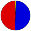
George W. Bush | Richard Cheney | Republican | | |
108,959 |
50.48% |
 |
John Kerry | John Edwards | Democratic-F.L. | | |
104,635 |
48.48% |
 |
Ralph Nader | Peter Camejo | Better Life | | |
1,109 |
0.51% |
|
Michael Badnarik | Richard Campagna | Libertarian | | |
334 |
0.15% |
|
David Cobb | Patricia LaMarche | Green | | |
237 |
0.11% |
|
Michael Peroutka | Charles Baldwin | Constitution | | |
204 |
0.09% |
|
Write-ins | - | - | | |
185 |
0.09% |
|
Thomas Harens | Jennifer Ryan | Christian Freedom | | |
128 |
0.06% |
|
Bill Van Auken | Jim Lawrence | Socialist Equality | | |
35 |
0.02% |
|
Róger Calero | Arrin Hawkins | Socialist Workers | | |
20 |
0.01% |
 |
Map Key
| Turnout
 |
 |
|
| Maps | County Township Map (m) |  |
 |
 |
| |
| Demographic Data
| 2010 Population: | 398,552 | Enum. | 2010 Population Density: | 270.2 | persons/km2 | | 2004 Population: | 377,143 | Est. | 2004 Population Density: | 255.7 | persons/km2 | | 2000 Population: | 355,904 | Enum. | 2000 Population Density: | 241.3 | persons/km2 | | Land Area (2000): | 1,475 | km2 | Annual Pop Growth Rate: | 1.1 | % |
| Data and Statistics:
- City and Town Data (Table) (m)
- City and Town Data (Graphs) (m)
- Precinct Data (Table) (m)
|
- Compare County Data by Year (Table) (m)
- Compare County Data by Year (Graphs) (m)
- Compare County Maps by Year (m)
| | Election Notes:
- Kerry party was listed on the ballot as Democratic-Farmer-Labor
|
| | |


