Note: The Google advertisement links below may advocate political positions that this site does not endorse.
 Presidential
Candidate
Vice Presidential
Candidate
Political
Party
Popular Vote
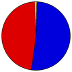
George W. BushRichard CheneyRepublican 72,508 51.69%
John KerryJohn EdwardsDemocratic 66,476 47.39%
Ralph NaderPeter CamejoIndependent 792 0.56%
YOther (+) - - 503 0.36%
Seal Map Key
 > 40%
 > 50%
 > 60%
 > 70%
Turnout
Voter Turnout Graph
Pie Chart
MapsCounty Township Map (m)
Town
Last Button
Per Vote Republican Button
Per Vote Democratic Button
Swing Map Button
Trend Map Button
 
Demographic Data

2010 Population:323,444Enum.2010 Population Density:409.9persons/km2
2004 Population:310,424Est.2004 Population Density:393.4persons/km2
2000 Population:297,490Enum.2000 Population Density:377.0persons/km2
Land Area (2000):789km2Annual Pop Growth Rate:0.8%

Data and Statistics:
  • City and Town Data (Table) (m)
  • City and Town Data (Graphs) (m)
  • Compare County Data by Year (Table) (m)
  • Compare County Data by Year (Graphs) (m)
  • Compare County Maps by Year (m)


National Results for 2004 - New Jersey Results for 2004 - Use Frame Navigation

Login

Terms of Use - DCMA Policy - Privacy Policy and Cookies


© Dave Leip's Atlas of U.S. Elections, LLC 2019 All Rights Reserved
Rocky Hill Borough 34035 Montgomery Township 34035 Millstone Borough 34035 Franklin Township 34035 Manville Borough 34035 South Bound Brook Borough 34035 Hillsborough Township 34035 Somerville Borough 34035 Bound Brook Borough 34035 Raritan Borough 34035 Green Brook Township 34035 Branchburg Township 34035 North Plainfield Borough 34035 Bridgewater Township 34035 Watchung Borough 34035 Warren Township 34035 Far Hills Borough 34035 Bedminster Township 34035 Peapack and Gladston Borough 34035 Bernards Township 34035 Bernardsville Borough 34035