| | Presidential
Candidate | Vice Presidential
Candidate | Political
Party | Popular Vote |
|---|
 |
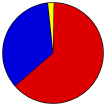
Barack H. Obama | Joseph R. Biden, Jr. | Democratic | | | | | |
2,694 |
63.11% |
 |
John S. McCain, III | Sarah Palin | Republican | | | | | |
1,490 |
34.90% |
 |
Ralph Nader | Matt Gonzalez | Independent | | | | | |
52 |
1.22% |
|
Bob Barr | Wayne A. Root | Libertarian | | | | | |
13 |
0.30% |
|
Write-ins | - | - | | | | | |
13 |
0.30% |
|
Róger Calero | Alyson Kennedy | Socialist Workers | | | | | |
3 |
0.07% |
|
Charles O. Baldwin | Darrell L. Castle | Constitution | | | | | |
2 |
0.05% |
|
Brian Moore | Stewart A. Alexander | Liberty Union | | | | | |
1 |
0.02% |
|
Gloria La Riva | Eugene Puryear | Socialism and Liberation | | | | | |
1 |
0.02% |
 |
Map Key
| Turnout
 |
 |
|
| Maps | County Township Map (m) |  |  |
 |
 |
 |
 |
| |
| Demographic Data
| 2010 Population: | 6,970 | Enum. | 2010 Population Density: | 32.6 | persons/km2 | | 2008 Population: | 7,211 | Est. | 2008 Population Density: | 33.7 | persons/km2 | | 2000 Population: | 6,901 | Enum. | 2000 Population Density: | 32.2 | persons/km2 | | Land Area (2000): | 214 | km2 | Annual Pop Growth Rate: | 0.1 | % |
| Data and Statistics:
- City and Town Data (Table) (m)
- City and Town Data (Graphs) (m)
- Precinct Data (Table) (m)
|
- Compare County Data by Year (Table) (m)
- Compare County Data by Year (Graphs) (m)
- Compare County Maps by Year (m)
| |
| | |


