


The 2010 Endorsements scripts for US Senate and for Governor have been upgraded to provide the ability for other members to comment on your endorsements. All existing endorsements are defaulted to comments off. To enable comments on your endorsements, simply update your endorsements map (no changes to actual endorsements is required), and, when you reach step 2 (after the map is generated) check “Yes” on the option to allow other members to comment on your endorsements.
Category Archives: New Feature
U.S. Senate Election Results Upgrade
The Atlas results database has been upgraded to support the event in which two U.S. Senate races occur in the same year from the same state. The term “class” has been added to distinguish between the elections. There are three U.S. Senate classes that alternate every two years – repeating every six. 2010 is a class 3 election. There also happen to be three Special Elections that are also taking place on November 2, 2010 – Delaware (Class 2), West Virginia (Class 1), and New York (Class 1). Delaware and West Virginia do not have a Class 3 Senate seat, and therefore have only one contest on November 2. New York, however, does have a Class 3 Senate seat and has two Senate contests on Nov 2. To support this, I’ve upgraded all general election contests from 1990 through 2010 – and all the past special two-senate-from-one-state contests not previously included in the results menus are now available. These include 1992 CA & ND, 1994 TN, 1996 KS, 2008 MS & WY and 2010 NY.
2010 Gubernatorial Polls
The 2010 Gubernatorial Election polls database and pages are now online. Follow the evolution of support for the candidates in the top state executive office. Use the information to help tune your 2010 Gubernatorial Predictions. The 2010 U.S. Senate polls database and pages are forthcoming as development continues to incorporate support for two elections in the state of New York.
2010 Predictions Now Available
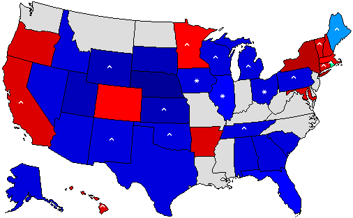 A very popular feature of The Atlas community are the Election Predictions. For 2010, the Gubernatorial and Senatorial election predictions are now online and active. A new feature this year adds the ability to predict the special election in states where the primary seat is already up for election. In addition, there is a new column in the prediction table that shows the status of the contest (for example: Open Republican seat or Democratic Incumbent running for reelection). So have a hand at electoral prognostication!
2009 Gubernatorial Predictions, Endorsements, and Polls
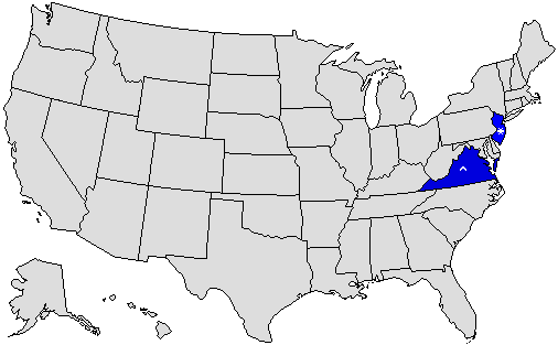 The 2009 Gubernatorial interactive features of Predictions, Polls, and Endorsements are now available. There are only two races this year – in New Jersey and Virginia.
UUorld GIS Software & Atlas Data
 The Atlas is partnering with UUorld (pronounced “World”) GIS software developer to provide election data in formats capable of being imported to the UUorld application. A link has been added to your myatlas page to the UUorld Export Script. All data sets purchased from the Atlas are available to you for export.
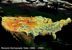
The application’s primary feature is the ability to extrude shapes in a three dimensional projection providing a geographic visual representation of relative data. 2-D mapping options are also available. One particular feature is the ability to produce animated time-series movies such the percent vote for Democratic Party Presidential candidates for the general elections between 1980 and 2004 (shown in this post). See some more examples of the Atlas data here. More data export options will be developed in the coming months. User feedback welcome.
*Update* UUorld is offering a $50 Rebate on the commercial version of UUorld with a receipt for an Atlas data purchase.
Election Night 2008 Timeline
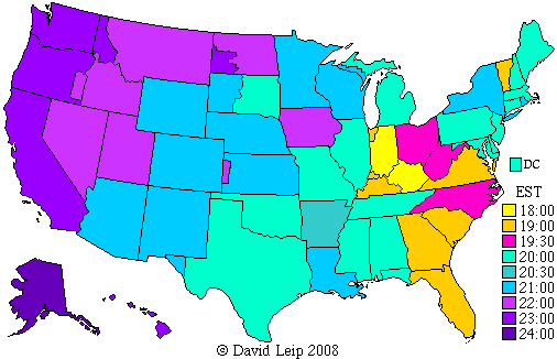 The 2008 Election Night Timeline is now available. Included are a national color-coded map of poll closing times and a table of the timeline for closing/call times for each state. Follow along on Election night as the states are called!
2008 Senatorial & Gubernatorial Endorsements
The Atlas feature to create user endorsements for 2008 Senatorial and Gubernatorial contests are now available. Endorse the candidates you support!
2008 Mock General Election
The Mock 2008 Presidential Election is now available. 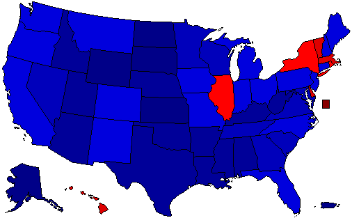 This year’s contest includes a feature that allows visitors to treat their vote as an endorsement. With this option selected, a small banner appears below the state avatar in Forum Posts. Click on over and cast your ballot!
New Blog Interactive Election Map Widgets
I have created a new method for posting election results in Blogs – an interactive election map “widget” – a small snipet that can be placed in the code section of a blog post. The map has mouse-over interactivity, including a county-level imagemap with the floating text box of results plus links to more detailed returns. Below is an example comparing the 2004 General Election Result in South Carolina to the 2008 Republican Primary in South Carolina.
The link for this code may be seen by clicking on the link titled “Blog Interactive Map Widget Code for this Contest” in the “Election Tools” section of any state (or national) summary page. The code can then be placed in an uselectionatlas.org weblog post (note in order to use this widget, you need to enable the pageview plugin on the “Plugins” tab in the admin section of you weblog. At this time, this widget can’t be used on other weblogs since iframes are generally not permitted using most blogging software.