| |
Presidential
Candidate | Vice Presidential
Candidate | Political
Party | Popular Vote | Electoral Vote |
 | William Clinton | Albert Gore Jr. | Democratic |
1,008,966 |
43.47% | 13 |
 | George Bush | J. Danforth Quayle | Republican |
995,252 |
42.88% | 0 |
 | H. Ross Perot | James Stockdale | Independent |
309,657 |
13.34% | 0 |
 | Andre Marrou | Nancy Lord | Libertarian |
7,110 |
0.31% | 0 |
| Other (+) | - | - |
148 |
0.01% | 0 |
 |
Map Key
| > 30% |
 |
 |
| > 40% |
 |
 |
| > 50% |
 |
 |
| > 60% |
 |
 |
| > 70% |
 |
|
| Turnout
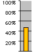 |  |  |
|
| Maps | 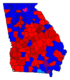 |  |  | | Pop. (m) | | Dem. (m) | | Rep. (m) | | Ind. (m) | | Swg (m) | | Tnd (m) |
| |
| Demographic Data
| 2000 Population: | 8,186,453 | Enum. | 2000 Population Density: | 54.6 | persons/km2 | | 1992 Population: | 6,817,203 | Est. | 1992 Population Density: | 45.5 | persons/km2 | | 1990 Population: | 6,478,149 | Enum. | 1990 Population Density: | 43.2 | persons/km2 | | Total Electoral Vote: | 13 | | Electoral Vote Density: | 524,400 | persons/EV | | Land Area (2000): | 149,976 | km2 | Annual Pop Growth Rate: | 2.4 | % |
| Presidential Electors:
- Method of Choosing:Popular Vote - Winner-Take-All
- Table of Presidential Electors for Georgia in 1992 (m)
| Election Data and Statistics:
| Election Tools
- Atlas Forum Image Code for Maps: County, Pop, Tnd, Swg
Data Sources:
- Source for Popular Vote data: Georgia Secretary of State, Official State of Georgia Tabulation by Counties for Presidential Electors ... General Election November 3, 1992 (Atlanta, 1992)
- Source for Population data: U.S. Census Bureau.
| Results for and Individual County:
|
|
| |


