| |
Presidential
Candidate | Vice Presidential
Candidate | Political
Party | Popular Vote | Electoral Vote |
 | William Clinton | Albert Gore Jr. | Democratic |
1,123,323 |
49.84% | 11 |
 | Robert Dole | Jack Kemp | Republican |
840,712 |
37.30% | 0 |
 | H. Ross Perot | Pat Choate | Reform |
201,003 |
8.92% | 0 |
 | Ralph Nader | Winona LaDuke | Independent |
60,322 |
2.68% | 0 |
| Harry Browne | Jo Jorgensen | Libertarian |
12,522 |
0.56% | 0 |
| Dr. John Hagelin | Dr. V. Tompkins | Natural Law |
6,076 |
0.27% | 0 |
| Howard Phillips | Herbert Titus | US Taxpayers |
4,578 |
0.20% | 0 |
| Charles Collins | Rosemary Giumarra | Independent |
2,374 |
0.11% | 0 |
| Monica Moorehead | Gloria La Riva | Workers World |
2,189 |
0.10% | 0 |
| James Harris | Laura Garza | Soc. Workers |
738 |
0.03% | 0 |
 |
Map Key
| Turnout
 |  |  |
|
| Maps | 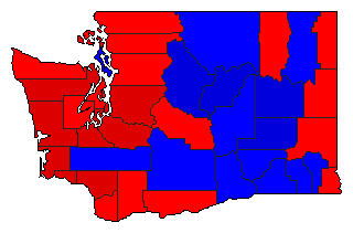 |  |  | | Pop. (m) | | Dem. (m) | | Rep. (m) | | Ref. (m) | | Swg (m) | | Tnd (m) |
| |
| Demographic Data
| 2000 Population: | 5,894,121 | Enum. | 2000 Population Density: | 34.2 | persons/km2 | | 1996 Population: | 5,569,753 | Est. | 1996 Population Density: | 32.3 | persons/km2 | | 1990 Population: | 4,866,669 | Enum. | 1990 Population Density: | 28.2 | persons/km2 | | Total Electoral Vote: | 11 | | Electoral Vote Density: | 506,341 | persons/EV | | Land Area (2000): | 172,348 | km2 | Annual Pop Growth Rate: | 1.9 | % |
| Election Data and Statistics:
| Election Tools
- Atlas Forum Image Code for Maps: County, Pop, Tnd, Swg
Data Sources:
- Source for Popular Vote data: Washington Secretary of State, Official Returns of the State General Election November 5, 1996 (Olympia, 1996)
- Source for Population data: U.S. Census Bureau.
| Results for and Individual County:
|
|
| |


