1916 Senatorial General Election Results - Montana
Note: The Google advertisement links below may advocate political positions that this site does not endorse.
Data for this Contest was Contributed by on 2023-09-20

  Senatorial
Candidate
Political
Party
Popular Vote
Henry L. MyersDemocratic 85,580 51.05%
Charles N. PrayRepublican 72,753 43.40%
Henry La BeauSocialist 9,292 5.54%
State Seal Map Key
 > 40%
 > 50%
 > 60%
 > 70%
Turnout
Voter Turnout Graph
Vote Pie Chart
Maps
  1916 Montana County Map of General Election Results for Senator  
County Button
Per Vote Democratic Button
Per Vote Republican Button
Per Vote Socialist Button
 
Demographic Data

1920 Population:548,889Enum.1920 Population Density:1.5persons/km2
1910 Population:376,053Enum.1910 Population Density:1.0persons/km2
Land Area (2000):376,979km2Annual Pop Growth Rate:3.9%

Election Data and Statistics:
  • County Data (Table) (m)
  • County Data (Graphs) (m)
Election Tools
Data Sources:
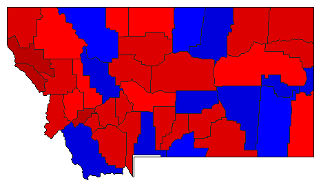
  • Source for Popular Vote data: Montana Secretary of State. Official Vote of the State of Montana at an Election Held November 7th, 1916, Montana Secretary of State (https://sosmt.gov/Portals/142/Elections/archives/1910s/1916_General_Statewide.pdf) (accessed 20 Sep 2023)
  • Source for Population data: U.S. Census Bureau.
Results for and Individual County:
  • (m)


Beaverhead County Big Horn County Blaine County Broadwater County Carbon County Cascade County Chouteau County Custer County Dawson County Deer Lodge County Fallon County Fergus County Flathead County Gallatin County Granite County Hill County Jefferson County Lewis and Clark County Lincoln County Madison County Meagher County Mineral County Missoula County Musselshell County Park County Phillips County Powell County Prairie County Ravalli County Richland County Rosebud County Sanders County Sheridan County Silver Bow County Stillwater County Sweet Grass County Teton County Toole County Valley County Wibaux County Yellowstone County