Home
2024
Election Results
Election Info
Weblog
Forum
Wiki
Search
Email
Login
Site Info
Store
1944 Senatorial Special Election Results - Oregon
Note: The Google advertisement links below may advocate political positions that this site does not endorse.
Data for this Contest was Contributed by on 2023-09-15
Senatorial
Candidate
Political
Party
Popular Vote
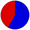
Guy Corden
Republican
260,631
57.54%
Willis Mahoney
Democratic
192,305
42.46%
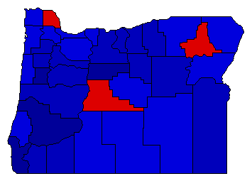
Map Key
> 40%
> 50%
> 60%
> 70%
Turnout
Maps
Election Notes:
Special election to fill remainder of the term of Charles McNary, who died February 25, 1944.
Demographic Data
1950 Population:
1,521,341
Enum.
1950 Population Density:
6.1
persons/km
2
1940 Population:
1,089,684
Enum.
1940 Population Density:
4.4
persons/km
2
Land Area (2000):
248,631
km
2
Annual Pop Growth Rate:
3.4
%
Election Data and Statistics:
County Data (Table)
(m)
County Data (Graphs)
(m)
Compare State Maps by Year
View All 1944 Oregon Maps
Election Tools
Atlas Forum
Image Code for Maps:
County
Data Sources:
Source for Popular Vote data: Oregon Secretary of State.
Abstract of Votes, Regular General Election, November 7, 1944
, Oregon Secretary of State (http://records.sos.state.or.us/ORSOSWebDrawer/Record/8411002) (accessed 15 Sep 2023)
Source for Population data: U.S. Census Bureau.
Results for and Individual County:
(m)
Choose Year
1996
1995
1960
1938
1918
1906
Choose Office
Choose State
Indiana
Massachusetts
Oregon Election Results Home
-
National Results for 1944
-
Use Frame Navigation
Login
Terms of Use
-
DCMA Policy
-
Privacy Policy and Cookies
©
Dave Leip's Atlas of U.S. Elections, LLC 2019 All Rights Reserved


