| |
Presidential
Candidate | Vice Presidential
Candidate | Political
Party | Popular Vote | Electoral Vote |
 | William Clinton | Albert Gore Jr. | Democratic |
1,025,935 |
47.54% | 11 |
 | Robert Dole | Jack Kemp | Republican |
890,016 |
41.24% | 0 |
 | H. Ross Perot | James Campbell | Reform |
217,188 |
10.06% | 0 |
 | Howard Phillips | Herbert Titus | US Taxpayer |
11,521 |
0.53% | 0 |
| Harry Browne | Jo Jorgensen | Libertarian |
10,522 |
0.49% | 0 |
| Other (+) | - | - |
2,883 |
0.13% | 0 |
 |
Map Key
| Turnout
 |  |  |
|
| Maps | 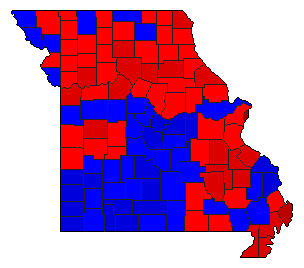 |  |  | | Pop. (m) | | Dem. (m) | | Rep. (m) | | Ref. (m) | | Swg (m) | | Tnd (m) |
| |
| Demographic Data
| 2000 Population: | 5,595,211 | Enum. | 2000 Population Density: | 31.4 | persons/km2 | | 1996 Population: | 5,431,553 | Est. | 1996 Population Density: | 30.4 | persons/km2 | | 1990 Population: | 5,116,901 | Enum. | 1990 Population Density: | 28.7 | persons/km2 | | Total Electoral Vote: | 11 | | Electoral Vote Density: | 493,778 | persons/EV | | Land Area (2000): | 178,414 | km2 | Annual Pop Growth Rate: | 0.9 | % |
| Election Data and Statistics:
| Election Tools
- Atlas Forum Image Code for Maps: County, Pop, Tnd, Swg
Data Sources:
- Source for Popular Vote data: Missouri Office of the Secretary of State, "President and Vice President General Election: November 5, 1996," Official Manual State of Missouri 1997-1998 (Jefferson City, 1997)
- Source for Population data: U.S. Census Bureau.
| Results for and Individual County:
|
|
| |


