| |
Presidential
Candidate | Vice Presidential
Candidate | Political
Party | Popular Vote | Electoral Vote |
 | William Clinton | Albert Gore Jr. | Democratic |
1,652,329 |
53.72% | 15 |
 | Robert Dole | Jack Kemp | Republican |
1,103,078 |
35.86% | 0 |
 | H. Ross Perot | Pat Choate | Independent |
262,134 |
8.52% | 0 |
 | Ralph Nader | Winona LaDuke | Independent |
32,465 |
1.06% | 0 |
| Harry Browne | Jo Jorgensen | Independent |
14,763 |
0.48% | 0 |
| Other (+) | - | - |
11,038 |
0.36% | 0 |
 |
Map Key
| Turnout
 |  |  |
|
| Maps | 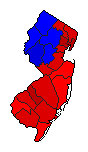 |  |  | | Pop. (m) | | Dem. (m) | | Rep. (m) | | Ind. (m) | | Swg (m) | | Tnd (m) |
| |
| Demographic Data
| 2000 Population: | 8,414,350 | Enum. | 2000 Population Density: | 438.0 | persons/km2 | | 1996 Population: | 8,149,596 | Est. | 1996 Population Density: | 424.2 | persons/km2 | | 1990 Population: | 7,747,750 | Enum. | 1990 Population Density: | 403.3 | persons/km2 | | Total Electoral Vote: | 15 | | Electoral Vote Density: | 543,306 | persons/EV | | Land Area (2000): | 19,211 | km2 | Annual Pop Growth Rate: | 0.8 | % |
| Election Data and Statistics:
| Election Tools
- Atlas Forum Image Code for Maps: County, Pop, Tnd, Swg
Data Sources:
- Source for Popular Vote data: New Jersey Department of Law and Public Safety. Division of Elections, Official Results Presidential Election November 5, 1996 (Trenton, 1996)
- Source for Population data: U.S. Census Bureau.
| Results for and Individual County:
|
|
| |


