| |
Presidential
Candidate | Vice Presidential
Candidate | Political
Party | Popular Vote | Electoral Vote |
 | Robert Dole | Jack Kemp | Republican |
691,848 |
45.80% | 8 |
 | William Clinton | Albert Gore Jr. | Democratic |
671,152 |
44.43% | 0 |
 | H. Ross Perot | Pat Choate | Reform |
99,629 |
6.59% | 0 |
 | Ralph Nader | Winona LaDuke | Green CO |
25,070 |
1.66% | 0 |
| Harry Browne | Jo Jorgensen | Libertarian |
12,392 |
0.82% | 0 |
| Other (+) | - | - |
10,613 |
0.70% | 0 |
 |
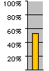
Map Key
| Turnout
 |  |  |
|
| Maps | 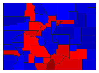 |  |  | | Pop. (m) | | Rep. (m) | | Dem. (m) | | Ref. (m) | | Swg (m) | | Tnd (m) |
| |
| Demographic Data
| 2000 Population: | 4,301,261 | Enum. | 2000 Population Density: | 16.0 | persons/km2 | | 1996 Population: | 3,919,972 | Est. | 1996 Population Density: | 14.6 | persons/km2 | | 1990 Population: | 3,294,473 | Enum. | 1990 Population Density: | 12.3 | persons/km2 | | Total Electoral Vote: | 8 | | Electoral Vote Density: | 489,997 | persons/EV | | Land Area (2000): | 268,627 | km2 | Annual Pop Growth Rate: | 2.7 | % |
| Election Data and Statistics:
| Election Tools
- Atlas Forum Image Code for Maps: County, Pop, Tnd, Swg
Data Sources:
- Source for Popular Vote data: Colorado Secretary of State, State of Colorado Abstract of Votes Cast 1995-1996 (Denver, 1997)
- Source for Population data: U.S. Census Bureau.
| Results for and Individual County:
|
|
| |


