2016 Presidential Democratic Primary Election Results - Muskegon County, MI
Note: The Google advertisement links below may advocate political positions that this site does not endorse.
 Presidential
Candidate
Home StatePolitical
Party
Popular Vote
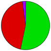
Bernie SandersVermontDemocratic 10,456 52.86%
Hillary ClintonNew YorkDemocratic 8,807 44.53%
Uncommitted-Democratic 440 2.22%
Martin O'MalleyMarylandDemocratic 51 0.26%
Roque 'Rocky' De La FuenteCaliforniaDemocratic 25 0.13%
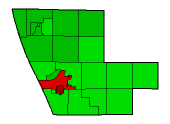
Seal Map Key
 > 20%
 > 30%
 > 40%
 > 50%
 > 60%
Turnout
Voter Turnout Graph
Pie Chart
Maps
2016 County Township Map
Town
Per Vote Democratic Button
 
Demographic Data

2016 Population:173,342Est.2016 Population Density:131.4persons/km2
2010 Population:172,188Enum.2010 Population Density:130.5persons/km2
Land Area (2000):1,319km2Annual Pop Growth Rate:0.1%

Data and Statistics:
  • City and Town Data (Table) (m)
  • City and Town Data (Graphs) (m)


    National Results for 2016 - Michigan Results for 2016 - Use Frame Navigation

    Login

    Terms of Use - DCMA Policy - Privacy Policy and Cookies


    © Dave Leip's Atlas of U.S. Elections, LLC 2019 All Rights Reserved
    Blue Lake Township 26121 Casnovia Township 26121 Cedar Creek Township 26121 Dalton Township 26121 Egelston Township 26121 Fruitland Township 26121 Fruitport Charter Township 26121 Holton Township 26121 Laketon Township 26121 Montague City 26121 Montague Township 26121 Moorland Township 26121 Muskegon City 26121 Muskegon Charter Township 26121 Muskegon Charter Township 26121 Muskegon Charter Township 26121 Muskegon Heights City 26121 North Muskegon City 26121 Norton Shores City 26121 Ravenna Township 26121 Roosevelt Park City 26121 Sullivan Township 26121 Whitehall City 26121 Whitehall Township 26121 White River Township 26121