Difference between revisions of "Chops"
| (10 intermediate revisions by the same user not shown) | |||
| Line 1: | Line 1: | ||
| − | Chops occur when a geographic unit is divided into one or more pieces to accommodate districts. For simplicity this article will | + | Chops are a measure of [[geographic integrity]]. Chops occur when a geographic unit is divided into one or more pieces to accommodate districts. For simplicity this article will use counties as the geographic unit and describe county chops, but the idea can extend to any other unit. |
| − | The presumption is that each county has an ideal placement with respect to a district. | + | The presumption is that each county has an ideal placement with respect to a district. Small counties are those with less population than a single district and the ideal configuration is for the county to be entirely within one district. Large counties are those with more population than a single district and the ideal configuration is to have the maximum number of whole districts within the county and the remainder in a single district. Ideally a county within the maximum deviation from [[population equality]] for a single district is set equal to a single district. |
| − | + | In general the preference is for chops to separate fewer rather than more people in a unit. A microchop is a chop that creates a piece of a county whose population is smaller than the maximum deviation for a single district. A macrochops is a chop large enough that the remainder of a unit after the largest fragment is removed is more than 10 times the maximum deviation for a single district. | |
| − | + | '''Geographic fragmentation''' looks at the number of chopped pieces in a county. Counties kept whole do not count, and districts entirely in a county do not count. Geographic fragmentation rewards plans that chop the fewest number of counties and plans that nest districts entirely within large counties. However, the first chop of a small county raises the geographic fragmentation by two instead of one. This can lead towards packing many chops into one county. | |
| − | + | '''Node fragmentation''' looks at the number of times a county has been divided to make a district. The count increases for each additional [[node]] created. Counties kept whole do not count and chopped counties count one less than the number of districts in that county. The first chop using node fragmentation counts one as does each subsequent chop. Node fragmentation places the same weight on one county chopped twice as it does two counties each chopped once. However, node fragmentation does not especially reward plans that keep districts entirely within a county. | |
| − | [[File:Chops5A.png|200px|right]] | + | |
| − | + | == Example: Small Counties == | |
| + | |||
| + | [[File:Chops5A.png|200px|right]]As an example consider a state of five counties as shown at right. The state needs to be divided into four districts and each county has 80% of the population for a district. Two plans are considered for comparison. | ||
| + | |||
| + | |||
| + | |||
| + | |||
| + | |||
| + | |||
| + | |||
| + | |||
| + | |||
| + | |||
| + | |||
| + | [[File:Chops5B.png|200px|right]]In the first plan the chops are all placed in county A. There is only one county that is chopped, but there are four chops in that county. Using geographic fragmentation this plan has a score of 4 which corresponds to the number of pieces in the chopped county. Using node fragmentation this plan has a score of 3 which corresponds to the number of times that the county was chopped to go from one piece to four pieces. | ||
| + | |||
| + | |||
| + | |||
| + | |||
| + | |||
| + | |||
| + | |||
| + | |||
| + | [[File:Chops5C.png|200px|right]]In the second plan the chops are spread out so that no county has more than two parts. This requires at least three counties chopped and counties B, C, and D are chopped. Using geographic fragmentation this plan has a score of 6 since there are three chopped counties with two pieces each. Using node fragmentation this plan has a score of 3 like the previous one, since there are three counties each with a single chop. | ||
| + | |||
| + | |||
| + | |||
| + | |||
| + | |||
| + | |||
| + | |||
| + | |||
| + | |||
| + | |||
| + | Notice that node fragmentation would treat these plans as equals, while geographic fragmentation results in a preference for the first plan. | ||
| + | |||
| + | |||
| + | == Example: Large County == | ||
| + | |||
| + | In the following example the state has five counties for three districts. Counties A and C are 50% of a district, counties B and D are 40% of a district, and county E is 120% of a district. | ||
| + | |||
| + | The lefthand plan nests the green district entirely in county E. The remainder of E in the red district is a '''bridge''' fragment. A bridge fragment links two whole counties that would not otherwise be connected through whole counties. Using geographic fragmentation the plan has a score of 1 for the bridge piece since the nested district does not count in the score. Using node fragmentation the plan has a score of 1 since there is one chop creating two pieces in county E. | ||
| + | |||
| + | The righthand plan avoids a bridge fragment but has no nested district in the large county E. Using geographic fragmentation this plan scores 2 counting each piece in E. Using node fragmentation the plan still scores 1 since there is only one chop in E. | ||
| + | |||
| + | As in the small county example node fragmentation treats the two plans equally, while geographic fragmentation has a preference. | ||
| + | |||
| + | [[File:Chops3AB.png|450px]] | ||
Latest revision as of 00:33, 7 April 2018
Chops are a measure of geographic integrity. Chops occur when a geographic unit is divided into one or more pieces to accommodate districts. For simplicity this article will use counties as the geographic unit and describe county chops, but the idea can extend to any other unit.
The presumption is that each county has an ideal placement with respect to a district. Small counties are those with less population than a single district and the ideal configuration is for the county to be entirely within one district. Large counties are those with more population than a single district and the ideal configuration is to have the maximum number of whole districts within the county and the remainder in a single district. Ideally a county within the maximum deviation from population equality for a single district is set equal to a single district.
In general the preference is for chops to separate fewer rather than more people in a unit. A microchop is a chop that creates a piece of a county whose population is smaller than the maximum deviation for a single district. A macrochops is a chop large enough that the remainder of a unit after the largest fragment is removed is more than 10 times the maximum deviation for a single district.
Geographic fragmentation looks at the number of chopped pieces in a county. Counties kept whole do not count, and districts entirely in a county do not count. Geographic fragmentation rewards plans that chop the fewest number of counties and plans that nest districts entirely within large counties. However, the first chop of a small county raises the geographic fragmentation by two instead of one. This can lead towards packing many chops into one county.
Node fragmentation looks at the number of times a county has been divided to make a district. The count increases for each additional node created. Counties kept whole do not count and chopped counties count one less than the number of districts in that county. The first chop using node fragmentation counts one as does each subsequent chop. Node fragmentation places the same weight on one county chopped twice as it does two counties each chopped once. However, node fragmentation does not especially reward plans that keep districts entirely within a county.
Example: Small Counties
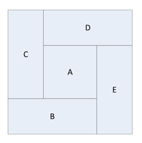
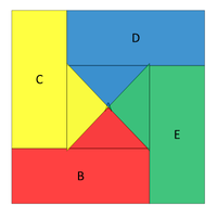
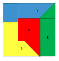
As an example consider a state of five counties as shown at right. The state needs to be divided into four districts and each county has 80% of the population for a district. Two plans are considered for comparison.
Notice that node fragmentation would treat these plans as equals, while geographic fragmentation results in a preference for the first plan.
Example: Large County
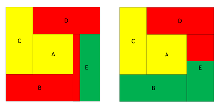
In the following example the state has five counties for three districts. Counties A and C are 50% of a district, counties B and D are 40% of a district, and county E is 120% of a district.
The lefthand plan nests the green district entirely in county E. The remainder of E in the red district is a bridge fragment. A bridge fragment links two whole counties that would not otherwise be connected through whole counties. Using geographic fragmentation the plan has a score of 1 for the bridge piece since the nested district does not count in the score. Using node fragmentation the plan has a score of 1 since there is one chop creating two pieces in county E.
The righthand plan avoids a bridge fragment but has no nested district in the large county E. Using geographic fragmentation this plan scores 2 counting each piece in E. Using node fragmentation the plan still scores 1 since there is only one chop in E.
As in the small county example node fragmentation treats the two plans equally, while geographic fragmentation has a preference.


