Note: The Google advertisement links below may advocate political positions that this site does not endorse.
  Presidential
Candidate
Vice Presidential
Candidate
Political
Party
Popular VoteElectoral Vote
John KerryJohn EdwardsDemocratic 396,842 53.57%4
George W. BushRichard CheneyRepublican 330,201 44.58%0
Ralph NaderPeter CamejoThe Better Life 8,069 1.09%0
David CobbPatricia LaMarcheGreen Independent 2,936 0.40%0
Michael BadnarikRichard CampagnaLibertarian 1,965 0.27%0
YOther (+) - - 739 0.10%0
Seal Map Key
 > 40%
 > 50%
 > 60%
 > 70%
Turnout
Voter Turnout Graph
Vote Pie ChartState Seal
Maps
  2004 Maine County Map of General Election Results for President  
County Button
2000 Button
Pop Button
Cong Dist Button
Town Button
Per Vote Democratic Button
Per Vote Republican Button
Swing Map Button
Trend Map Button
 
Demographic Data

2010 Population:1,328,361Enum.2010 Population Density:16.6persons/km2
2004 Population:1,313,688Est.2004 Population Density:16.4persons/km2
2000 Population:1,274,923Enum.2000 Population Density:16.0persons/km2
Total Electoral Vote:4Electoral Vote Density:328,422persons/EV
Land Area (2000):79,931km2Annual Pop Growth Rate:0.4%

Presidential Electors:
Election Data and Statistics:
Election Tools
Data Sources:
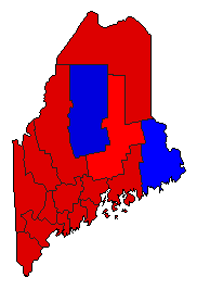
  • Source for Popular Vote data: Maine Department of the Secretary of State. Bureau of Corporations, Elections, and Commissions. General Election Tabulations November 2, 2004 President of the United States, Maine Department of the Secretary of State. Bureau of Corporations, Elections, and Commissions ( ) (accessed 07 Nov 2004)
  • Source for Population data: U.S. Census Bureau.
Results for and Individual County:
Primary Documentation:
  • 2004 Certificate of Ascertainment (m)
  • 2004 Certificate of Vote (m)
The 2004 Campaign:


Androscoggin County Aroostook County Cumberland County Franklin County Hancock County Kennebec County Knox County Lincoln County Oxford County Penobscot County Piscataquis County Sagadahoc County Somerset County Waldo County Washington County York County