Note: The Google advertisement links below may advocate political positions that this site does not endorse.
Data for this Contest was Contributed by on 2023-02-22
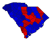
  Agriculture Commissioner
Candidate
Political
Party
Popular Vote
Hugh WeathersRepublican 792,260 60.11%
Tom ElliotDemocratic 525,229 39.85%
Write-ins- 533 0.04%
State Seal Map Key
 > 40%
 > 50%
 > 60%
 > 70%
Turnout
Voter Turnout Graph
Vote Pie Chart
Maps
  2010 South Carolina County Map of General Election Results for Agriculture Commissioner  
County Button
Pop Button
Per Vote Republican Button
Per Vote Democratic Button
 
Demographic Data

2010 Population:4,625,364Enum.2010 Population Density:59.3persons/km2
2000 Population:4,012,012Enum.2000 Population Density:51.4persons/km2
Land Area (2000):77,983km2Annual Pop Growth Rate:1.4%

Election Data and Statistics:
Election Tools
Data Sources:
  • Source for Popular Vote data: South Carolina State Election Commission. 2010 Results Reporting, South Carolina State Election Commission (http://http://www.enr-scvotes.org/SC/19077/40028/en/summary.html) (accessed 22 Feb 2023)
  • Source for Population data: U.S. Census Bureau.
Results for and Individual County:


Abbeville County Aiken County Allendale County Anderson County Bamberg County Barnwell County Beaufort County Berkeley County Calhoun County Charleston County Cherokee County Chester County Chesterfield County Clarendon County Colleton County Darlington County Dillon County Dorchester County Edgefield County Fairfield County Florence County Georgetown County Greenville County Greenwood County Hampton County Horry County Jasper County Kershaw County Lancaster County Laurens County Lee County Lexington County McCormick County Marion County Marlboro County Newberry County Oconee County Orangeburg County Pickens County Richland County Saluda County Spartanburg County Sumter County Union County Williamsburg County York County