Home
2024
Election Results
Election Info
Weblog
Forum
Wiki
Search
Email
Login
Site Info
Store
2012 Senatorial General Election Results
Note: The Google advertisement links below may advocate political positions that this site does not endorse.
Senatorial
Candidate
Political
Party
Popular Vote
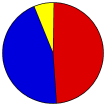
Jon Tester
Democratic
236,123
48.58%
Denny Rehberg
Republican
218,051
44.86%
Dan Cox
Libertarian
31,892
6.56%
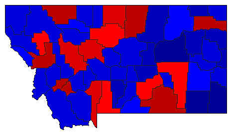
Map Key
> 40%
> 50%
> 60%
> 70%
Turnout
Maps
Demographic Data
2012 Population:
1,004,168
Est.
2012 Population Density:
2.7
persons/km
2
2010 Population:
989,415
Enum.
2010 Population Density:
2.6
persons/km
2
Land Area (2000):
376,979
km
2
Annual Pop Growth Rate:
0.7
%
Election Data and Statistics:
County Data (Table)
(m)
County Data (Graphs)
Purchase Detailed Data
Compare State Data by Year (Table)
Compare State Data by Year (Graphs)
View All 2012 Montana Data
Compare State Maps by Year
View All 2012 Montana Maps
Election Tools
Atlas Forum
Image Code for Maps:
County
,
Pop
,
Tnd
,
Swg
Data Sources:
Source for Popular Vote data: Montana Secretary of State.
2012 Statewide General Election Canvass
, Montana Secretary of State (http://sos.mt.gov/elections/2012/2012_General_Canvass.pdf ) (accessed 29 Nov 2012)
Source for Population data: U.S. Census Bureau.
Results for and Individual County:
Beaverhead County
Big Horn County
Blaine County
Broadwater County
Carbon County
Carter County
Cascade County
Chouteau County
Custer County
Daniels County
Dawson County
Deer Lodge County
Fallon County
Fergus County
Flathead County
Gallatin County
Garfield County
Glacier County
Golden Valley County
Granite County
Hill County
Jefferson County
Judith Basin County
Lake County
Lewis and Clark County
Liberty County
Lincoln County
McCone County
Madison County
Meagher County
Mineral County
Missoula County
Musselshell County
Park County
Petroleum County
Phillips County
Pondera County
Powder River County
Powell County
Prairie County
Ravalli County
Richland County
Roosevelt County
Rosebud County
Sanders County
Sheridan County
Silver Bow County
Stillwater County
Sweet Grass County
Teton County
Toole County
Treasure County
Valley County
Wheatland County
Wibaux County
Yellowstone County
Primary Documentation:
2012 Official County Documents
The 2012 Campaign:
Pre-Election Polls
< 2008
Choose Year
2020
2018
2014
2008
2006
2002
2000
1996
1994
1990
1988
1984
1982
1978
1976
1972
1970
1966
1964
1960
1958
1954
1952
1948
1946
1942
1940
1936
1934
1930
1928
1924
1922
1918
1916
1912
Choose Office
President
US Representative
Governor
Secretary of State
Attorney General
State Auditor
LR-120
LR-121
LR-122
IR-124
I-166
Choose State
Arizona Class 1
California Class 1
Connecticut Class 1
Delaware Class 1
Florida Class 1
Hawaii Class 1
Indiana Class 1
Maine Class 1
Maryland Class 1
Massachusetts Class 1
Michigan Class 1
Minnesota Class 1
Mississippi Class 1
Missouri Class 1
Nebraska Class 1
Nevada Class 1
New Jersey Class 1
New Mexico Class 1
New York Class 1
North Dakota Class 1
Ohio Class 1
Pennsylvania Class 1
Rhode Island Class 1
Tennessee Class 1
Texas Class 1
Utah Class 1
Vermont Class 1
Virginia Class 1
Washington Class 1
West Virginia Class 1
Wisconsin Class 1
Wyoming Class 1
2014 >
Montana Election Results Home
-
National Results for 2012
-
Use Frame Navigation
Login
Terms of Use
-
DCMA Policy
-
Privacy Policy and Cookies
©
Dave Leip's Atlas of U.S. Elections, LLC 2019 All Rights Reserved


