Home
2024
Election Results
Election Info
Weblog
Forum
Wiki
Search
Email
Login
Site Info
Store
2010 Senatorial General Election Results
Note: The Google advertisement links below may advocate political positions that this site does not endorse.
Senatorial
Candidate
Political
Party
Popular Vote
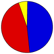
Mark S. Kirk
Republican
1,778,698
48.01%
Alexander Giannoulias
Democratic
1,719,478
46.42%
LeAlan M. Jones
Green
117,914
3.18%
Michael Labno
Libertarian
87,247
2.36%
Other (
+
)
-
1,136
0.03%
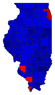
Map Key
> 40%
> 50%
> 60%
> 70%
Turnout
Maps
Demographic Data
2010 Population:
12,830,632
Enum.
2010 Population Density:
89.1
persons/km
2
2000 Population:
12,419,293
Enum.
2000 Population Density:
86.3
persons/km
2
Land Area (2000):
143,961
km
2
Annual Pop Growth Rate:
0.3
%
Election Data and Statistics:
County Data (Table)
(m)
County Data (Graphs)
Purchase Detailed Data
Compare State Data by Year (Table)
Compare State Data by Year (Graphs)
View All 2010 Illinois Data
Compare State Maps by Year
View All 2010 Illinois Maps
Election Tools
Atlas Forum
Image Code for Maps:
County
,
Pop
,
Tnd
,
Swg
Data Sources:
Source for Popular Vote data: Illinois State Board of Elections.
General Election - 11/2/2010 United States Senator
, Illinois State Board of Elections ( ) (accessed 03 Dec 2010)
Source for Population data: U.S. Census Bureau.
Results for and Individual County:
Adams County
Alexander County
Bond County
Boone County
Brown County
Bureau County
Calhoun County
Carroll County
Cass County
Champaign County
Christian County
Clark County
Clay County
Clinton County
Coles County
Cook County
Crawford County
Cumberland County
DeKalb County
De Witt County
Douglas County
DuPage County
Edgar County
Edwards County
Effingham County
Fayette County
Ford County
Franklin County
Fulton County
Gallatin County
Greene County
Grundy County
Hamilton County
Hancock County
Hardin County
Henderson County
Henry County
Iroquois County
Jackson County
Jasper County
Jefferson County
Jersey County
Jo Daviess County
Johnson County
Kane County
Kankakee County
Kendall County
Knox County
Lake County
LaSalle County
Lawrence County
Lee County
Livingston County
Logan County
McDonough County
McHenry County
McLean County
Macon County
Macoupin County
Madison County
Marion County
Marshall County
Mason County
Massac County
Menard County
Mercer County
Monroe County
Montgomery County
Morgan County
Moultrie County
Ogle County
Peoria County
Perry County
Piatt County
Pike County
Pope County
Pulaski County
Putnam County
Randolph County
Richland County
Rock Island County
St. Clair County
Saline County
Sangamon County
Schuyler County
Scott County
Shelby County
Stark County
Stephenson County
Tazewell County
Union County
Vermilion County
Wabash County
Warren County
Washington County
Wayne County
White County
Whiteside County
Will County
Williamson County
Winnebago County
Woodford County
Primary Documentation:
2010 Official County Documents
The 2010 Campaign:
Pre-Election Polls
< 2008
Choose Year
2022
2020
2016
2014
2008
2004
2002
1998
1996
1992
1990
1986
1984
1980
1978
1974
1972
1970
1968
1966
1962
1960
1956
1954
1950
1948
1944
1942
1940
1938
1936
1932
1930
1926
1924
1920
1918
1914
Choose Office
Governor
Secretary of State
State Treasurer
Attorney General
Comptroller General
Proposed Recall Amendment
Choose State
Alabama Class 3
Alaska Class 3
Arizona Class 3
Arkansas Class 3
California Class 3
Colorado Class 3
Connecticut Class 3
Delaware Class 2
Florida Class 3
Georgia Class 3
Hawaii Class 3
Idaho Class 3
Indiana Class 3
Iowa Class 3
Kansas Class 3
Kentucky Class 3
Louisiana Class 3
Maryland Class 3
Missouri Class 3
Nevada Class 3
New Hampshire Class 3
New York Class 1
New York Class 3
North Carolina Class 3
North Dakota Class 3
Ohio Class 3
Oklahoma Class 3
Oregon Class 3
Pennsylvania Class 3
South Carolina Class 3
South Dakota Class 3
Utah Class 3
Vermont Class 3
Washington Class 3
West Virginia Class 1
Wisconsin Class 3
2014 >
Illinois Election Results Home
-
National Results for 2010
-
Use Frame Navigation
Login
Terms of Use
-
DCMA Policy
-
Privacy Policy and Cookies
©
Dave Leip's Atlas of U.S. Elections, LLC 2019 All Rights Reserved


