Tag Archives: Map

Pennsylvania 2012 Presidential Election Results Map by Municipality

PA Map

Pennsylvania 2012 Presidential Election Result Map by Municipality

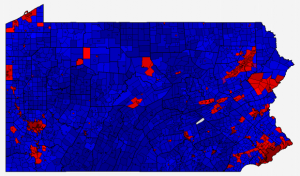
The Pennsylvania 2012 presidential election results map by Municipality (City, Borough, Township) is now complete.  Mitt Romney and Paul Ryan won a total of 2,031 municipalities while Barack Obama and Joe Biden won in 524 (11 were ties).  This is a pickup for the Republican ticket vs. 2008, of 234 municipalities.  Similar to many other states, the municipalities with the largest number of votes cast voted overwhelmingly Democratic, with Obama/Biden winning all of the top ten (Philadelphia, Pittsburgh, Allentown, Upper Darby, Erie, Lower Merion, Abington, Haverford, Scranton, and Millcreek) with a net margin of 656,882 votes.  The bulk of the margin votes are from the city of Philadelphia where Obama received 85.2% of the vote, resulting in a margin of 492,339 votes.  Romney’s largest margin in any municipality is 6,714 votes in Hampfield Township in Westmoreland County.  The total aggregated margin in all 2,031 municipalities won by Romney is 696,033, slightly more than the Obama margin in the ten municipalities listed above.  Full details, including party and swing maps can be viewed on the Pennsylvania 2012 Town page.  The forum topic is located here.

For members, there are now available county township maps on the individual county results pages.  In addition, the same maps and data are now available for President in the general elections of 2000, 2004, and 2008.

Wisconsin 2002 Gubernatorial Map by Municipality

Wisconsin 2002 Gubernatorial Election Result Map by Municipality

Wisconsin 2002 Gubernatorial Election Result Map by Municipality

At right is the Wisconsin 2002 General Election Result map for Governor by municipality.  This contest was between incumbent Republican Governor Scott McCallum (whom assumed office when Governor Tommy Thompson resigned to become the U.S. Secretary of Health and Human Services in January of 2001), the Democratic candidate Attorney General Jim Doyle, the Libertarian Mayor of Tomah Ed Thompson (the younger brother of former Governor Tommy Thompson), the Green party candidate Jim Young, and several other minor party candidates.  The statewide results of the election are summarized in the table below (full statewide results available  here):

Wisconsin 2002 General Election Result for Governor

 Gubernatorial
Candidate
Lt. Gubernatorial CandidatePolitical PartyPopular Vote%
James DoyleBarbara LawtonDemocratic800,51545.09%
Scott McCallumMargaret FarrowRepublican734,77941.39%
A. Ed ThompsonMartin ReynoldsLibertarian185,45510.45%
James YoungJeff PetersonWI Green44,1112.48%
Others--10,4890.59%

The results show an even split in the number of municipalities carried by Republican Scott McCallum and Democrat James Doyle.  Doyle won 896 municipalities, with strong showing in the City of Milwaukee, Dane County through the central part of the state and in the Northwest counties of Douglas, Bayfield, and Ashland.   Scott McCallum won in 905 municipalities, showing strength in the east of the state, from the Milwaukee western suburbs, north and east through the Eastern Ridges and Lowlands.  Libertarian Candidate Ed Thompson won 72 municipalities, mostly centered around his home City of Tomah (where he won Monroe County as well as neighboring Juneau County).  The overall margin of victory for James Doyle was 65,736 votes – fewer than his 93,126 vote margin in just two municipalities – Milwaukee, where he won 65.8% to 26.4% over his Republican Challenger, a margin of 55,420 votes and in Madison, where he won 62.8% to 18.8% (with 10.5% for Ed Thompson), a margin of 37,706 votes.

The candidates’ best counties with more than 1,000 votes are

  • Doyle: Superior (Douglas County) with 68.2% to 23.4% for McCallum and 4.5% for Thompson
  • McCallum: Oostburg (Sheboygan County) with 75.9% to 24.14% for Doyle and 5.15% for Thompson
  • Thompson: Tomah (Monroe County) with 55.8% to 22.4% for Doyle and 20.4% for McCallum

More information and maps are available on the Atlas town map page for the 2002 Gubernatorial Results – Wisconsin.  Atlas Forum topic on this result is located here.