Monthly Archives: October 2004

Election Week 2004

The plan for Election Week: Starting Monday, the main election result database will be off-line. Site members with Individual, Group, or Student licenses will continue to have access. This is necessary in order to reduce server load and conserve on bandwidth. I apologize for any inconvenience that this may cause.
Election predictions will close at 11pm EST on Monday. The polls close on the Mock Election at 5pm EST on Tuesday.

On Tuesday, I plan to update the time-line once every 30 minutes at about 10 past and 40 past each hour. State and county-level results will be posted once states reach ~ 90% precinct reporting, but not starting until around 10pm. On Wednesday morning, preliminary state and county data will be on-line. County maps will also be available. CD maps and data are only availble for those nice states with boundaries that do not cross county/town lines.

The 2004 election results will be available linked from the home page and the 2004 index page ( the national link page). Note that non-site-members will see ads with these pages. This is temporary during the high-bandwidth days. On Tuesday, the 2004 menu options will also appear in the main database for members to access.

GIS User Spotlight

Award GIF Today, the Atlas, is featuerd as the GISuser Spotlight at GISuser.com. The description below can be seen at this link.
“A casual search on the Internet for Presidential election maps will turn up loads of “hits”, however. one resource not to be missed is Dave Leip’s Atlas of US Presidential Elections. The site is rich with data and results from past elections and offers some clever maps. Not to be missed are the 2004 confidence and prediction maps.

Dave Leip’s USelectionatlas.org is an interesting resource that was started as a paper hobby after the 1992 Presidential Election. Dave was 22 and attending graduate school at MIT at the time when he made a photocopy of a U.S. map (with county boundaries) from one of the libraries and filled in counties with colored pen according to the winner. This effort spawned the idea for the wesbite and it’s been going strong ever since.

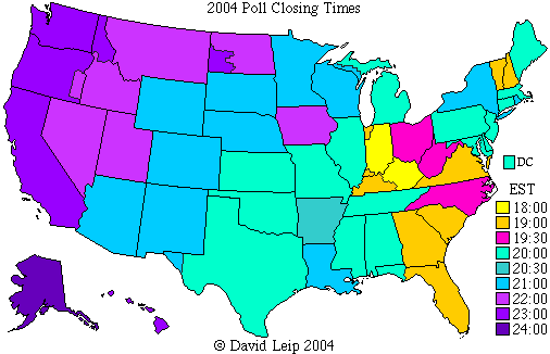
The resource provides valuable election data pointers and information as well as some great historical information, useful weblinks, a weblog, and some great maps. Note, back in 2000 I actually bestowed Dave a site of the week award from a previous resource that I was running. Some very noteworthy stops on the site include the 2004 prediction map and the mock election where visitors can cast a vote. Also, Dave has posted a map showing the closing time of polls.. this could be very useful for the TV networks as you might recall back in 2000 when a major network screwed up and began airing results prior to polls closing in Florida!”