


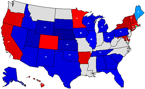
The map at the right shows a small version of the statewide results in Washington of the 2008 General Election for President by precinct (Obama in Red, McCain in Blue). This was made possible because the Washington Secretary of State has posted all the precinct-level GIS shape files. Most of the shape files line up with the county precinct data (although there are a number of discrepancies). The map link to the right brings you to the forum topic discussion on the 2008 Presidential Results by Precinct in Washington. The maps provide a very detailed geographic breakdown of the results, clearly showing the urban-rural split that has developed between the Republican and Democratic regions of support. Additional tweaking of the map is planned to incorporate the closest match to precinct boundaries used in the 2008 General Election for several counties.
Massachusetts Special Senate Election Results
The preliminary (unofficial) results of the 2010 Massachusetts Special Senate Election are available. In a surprise, Republican candidate Scott Brown defeated Democratic candidate Martha Coakley 52% to 47%. This result is actually very similar to the 2002 Gubernatorial Election Result where Mitt Romney defeated Shannon O’Brien by 5 percentage points (50% – 45%). Also, interestingly, the voter turnout for the snowy January 19 Special Election actually exceeded the turnout in both the 2002 and 2006 General Elections (preliminary figures show 2,249,026 votes in the special election vs. 2,194,179 votes in the 2002 General Election and 2,219,779 votes in the 2006 General Election).
2010 Gubernatorial Polls
The 2010 Gubernatorial Election polls database and pages are now online. Follow the evolution of support for the candidates in the top state executive office. Use the information to help tune your 2010 Gubernatorial Predictions. The 2010 U.S. Senate polls database and pages are forthcoming as development continues to incorporate support for two elections in the state of New York.
2010 Predictions Now Available
 A very popular feature of The Atlas community are the Election Predictions. For 2010, the Gubernatorial and Senatorial election predictions are now online and active. A new feature this year adds the ability to predict the special election in states where the primary seat is already up for election. In addition, there is a new column in the prediction table that shows the status of the contest (for example: Open Republican seat or Democratic Incumbent running for reelection). So have a hand at electoral prognostication!
2008 Data Files – Updates and New Voter Turnout
The 2008 data files for US President, US Senate, US House of Representatives, and Governors have been updated – these mostly include updates to Massachusetts – which only recently released “Public Document #43 – Massachusetts Election Statistics” – the only official data to the city and town level. The files also include several corrections to the official data discovered during compilation of precinct returns. These files are available for immediate download on your myatlas page (for previously purchased files.
A new 2008 voter registration and turnout file is also now available on the store page.
2009 Gubernatorial Predictions, Endorsements, and Polls
 The 2009 Gubernatorial interactive features of Predictions, Polls, and Endorsements are now available. There are only two races this year – in New Jersey and Virginia.
New York Township Map 2008
The 2008 New York Presidential General Election township map is now complete. . The precinct data was collected by contacting each of the 57 (non-New York City) Counties individually. The precinct data was aggregated by City and Town to produce this map.
Obama was victorious in 372 cities and towns to McCain’s 623 (there were two ties). However, Obama’s 372 victories were in places of considerably higher population – those 372 cities and towns cast 5,961,925 votes for Presidential Candidates, whereas in McCain’s 623 cities, and towns, a far less 1,679,564 votes were cast.
Relative to 2004, Obama increased Democratic victories by 154 (a 70% increase), many of the Republican-to-Democratic flips were in Upstate suburbs, the North Country (Northern Adirondacks and Quebec border), and in the Catskill region. Three towns flipped from Kerry to McCain (Throop (Cayuga), Brant (Erie), and Sangerfield (Oneida)).
One Decade
Today, January 24, 2009 is exactly one decade since the counter on the home page was added – and since then, 4,131,137 visitors have viewed the page (the counter was set up not to count duplicate visits in the same day). Certainly a lot has changed – many more features and much more information have been added to the site in those years. May there be many more years (and decades) to come!
2008 Data Files Updated
The 2008 General Election data files for President, Senate, Governor, and *New* U.S. House of Representatives have been updated to official results for all states except for Massachusetts. After repeated contacts through the internet and phone, I went in person to the Elections Office at the Secretary of the Commonwealth here in Boston, only to be told the same answer. They will not release any town or county election figures until the publication of Public Document #43, due out sometime later this year (they said perhaps as early as April).
The Presidential data set includes additional figures for write-in votes in multiple states that are not included in the official documents or reports published by the state agencies, rather I’ve been collecting these data from individual county reports. These data will continue to be updated and added to throughout the coming months.
As mentioned above, also available is a data set for U.S. House of Representatives, including data by congressional district and votes by party by county. Additional House data sets for previous years (back to 2000) are being compiled and will be available soon.
Preliminary 2008 Presidential Data File
A preliminary version of the 2008 County and New England Township data file is available on the store page. This file will be updated in the coming days/weeks as the data from the many states become official. The 2008 Senate and Gubernatorial files will also be available soon. As always, purchases of preliminary data are eligible for free updates.